
Researched & checked — 3 Nov 2026
Tawang: The Monastery, Sela Pass and the Inner Line Permit, Planned on Official Facts
NEW Published 3 November 2026
Tawang is planned on permissions and altitudes before it is planned on sights: an Inner Line Permit that the state issues for 15 days at a time, a monastery the district administration calls India's largest, a pass at about 13,700 feet that a new tunnel now ducks beneath, and a border excursion that needs a second clearance from the Deputy Commissioner and the Army. Each is taken here from the Tawang district administration, Arunachal Tourism, the NIC and the Press Information Bureau.
Indian visitors need an Inner Line Permit (ILP) — the district administration confirms it is mandatory for all domestic Indian visitors, applied for online on the state's e-ILP portal or offline at Arunachal House counters; the NIC records the temporary-visitor permit as valid for 15 days and extendable. Foreign nationals need a Protected Area Permit (PAP), processed through authorised agencies. In Tawang, the monastery of Galden Namgey Lhatse — founded in the 17th century — is India's largest monastery and holds a 28-foot gilded Buddha. The road crosses Sela Pass at about 13,700 feet; since 9 March 2024 the BRO's Sela Tunnel at 13,000 feet (₹825 crore) has given Tawang all-weather connectivity beneath it. Bum La (15,200 feet) needs an additional clearance from the DC Office in Tawang and the Indian Army.
SECTION 01Tawang Monastery: Galden Namgey Lhatse, India's Largest Monastery
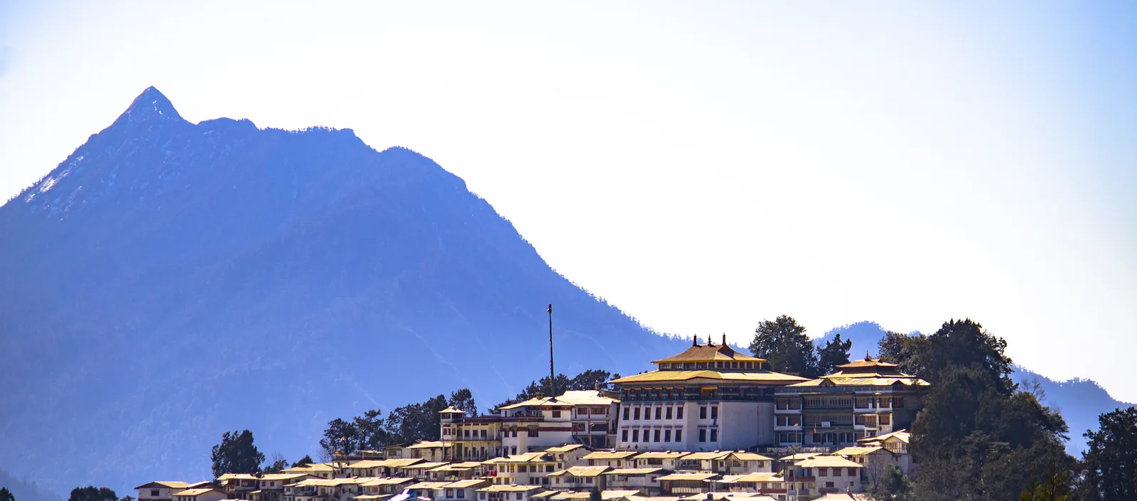
Everything in Tawang is measured against the monastery on the ridge. Arunachal Tourism's account is the one this guide follows: Tawang Monastery is an important seat of Mahayana Buddhism, a world-famous monastery of the Gelukpa school, founded during the 17th century by Mera Lama Lodre Gyaltso, a contemporary of the 5th Dalai Lama. The department calls it Asia's second largest monastery and India's largest, and records that it controls 17 gompas in the region. The district administration's phrasing matches: a 400-year-old monastery, India's largest and the second largest in the world after the Potala Palace in Lhasa, standing at the 10,000 feet the state circuit assigns to it. There is no stronger official channel than these two — the monastery publishes no website of its own that could be found for this guide — and none is needed: the building's scale is the argument.
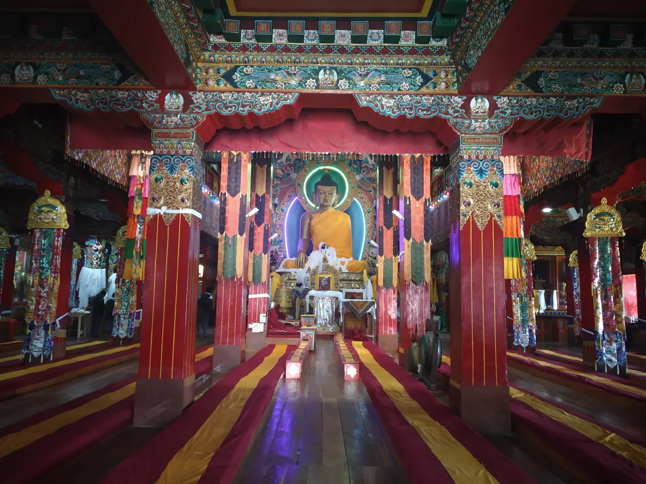
Inside, the published highlights are specific. The department picks out the imposing three-storied assembly hall and the 28 ft high golden statue of Lord Buddha — the district administration describes the same figure as a 28-foot gilded Buddha statue. Beside the hall sits a big library with an impressive collection of ancient books and manuscripts; the department names the treasures directly: the famous Buddhist gold-inscribed scriptures, the Kangyur and Tangyur, are preserved here. Plan the visit as the complex deserves: it is a working monastery that anchors a town, not a museum with a turnstile.
One companion sight belongs in the same morning. A short distance away stands Urgyelling Monastery, which the state department describes as sacred because it is the birth place of Thangyang Gyatso, the sixth Dalai Lama — the district administration likewise presents Tawang itself as the birthplace of the 6th Dalai Lama. The department also names the town's nunneries — Bramadung Chung, Sengsarbu and Gyanggong Ani Gompas — with the Ani Gompa counted among the oldest in the country. Two honest limits before you go: no official page read for this guide publishes the monastery's visiting hours or any entry fee, so neither is printed here; arrive in daylight, and let the monastery's own notice boards and attendants set the terms on the day.
SECTION 02The Inner Line Permit: The Paper That Opens the Gate
Begin with what the document is, in the words of the National Informatics Centre's official explainer. The Inner Line Permit is an official travel document issued to allow inward travel of an Indian citizen into a protected area for a limited period; it is obligatory for Indian citizens from outside the state, and it descends from the Bengal Eastern Frontier Regulation of 1873. For Arunachal Pradesh, the NIC records, the permit is issued by the Secretary (Political) of the Government of Arunachal Pradesh and is required for entering the state through any of the check gates across the interstate border with Assam or Nagaland — on the Tawang road, the gate you will actually meet is Bhalukpong, which the state department calls the entry point to Arunachal. The same explainer offers the traveller one comfort: ILPs valid for tourism purposes are granted as a matter of routine. This is a formality to complete, not a test to pass — but it is a formality, and the gate will ask.
The application runs on two channels, and both are official. The Tawang district administration states the position in one line: the ILP is mandatory for all domestic Indian visitors, available online at the state's e-ILP portal (eilp.arunachal.gov.in) or offline from Arunachal House counters in Guwahati, Tezpur, Kolkata and Delhi. The NIC adds the in-state channel: application offline or manually at any Deputy Commissioner's office in the state, and its explainer's own visit link points to the same e-ILP portal. On duration, the NIC is precise: an ILP for temporary visitors is valid for 15 days and can be extended, while the permit for those taking employment in the state, and their immediate family, runs for a year. Fifteen days is comfortably longer than any Tawang circuit needs, and the extension route exists if the mountains slow you down. Apply before you leave home, keep the issued permit with your identity document, and expect to show both at the check gate.
On the fee, this guide follows its rule. The permit is paid for when you apply, but no ILP fee is printed here: the e-ILP portal's own fee schedule could not be read when this guide was checked — the portal did not load through this pass's tools — and the figures quoted on unofficial pages disagree with each other, with ₹100 and ₹300/₹500 both in circulation for different permit categories. Rather than guess, the guide prints the mechanism: the amount is whatever the official portal itself presents for the permit you select, and it should be paid there and nowhere else. Do not buy a permit from a third-party site at a markup; the district administration names the official portal, and that is the whole list.
Foreign nationals travel under a different document entirely. The district administration states it without elaboration: a Protected Area Permit (PAP) is mandatory for foreign nationals, processed through authorized agencies. The ILP system described above is built for Indian citizens, and the e-ILP portal is not the foreign visitor's route. Beyond the district's sentence, official text read for this guide does not set out the PAP's fee, validity or group rules, so none are printed here; a foreign visitor should arrange the permit through an authorised agency well before travel, and should note now what Section 05 makes plain — the border excursion to Bum La is controlled separately again, by the Deputy Commissioner's office and the Army.
SECTION 03The Road In: Tezpur, Bhalukpong and the Bomdila–Dirang Climb
There is one road to Tawang, and the state tourism department publishes it as a circuit with the distances attached: the circuit covers 350 km starting from Tezpur in Assam to the 17th century Tawang Monastery, on the Balipara–Chariduar–Tawang road. Most travellers reach its start from Guwahati: Arunachal Tourism names Lokpriya Gopinath Bordoloi International Airport, Guwahati, as the nearest international airport, roughly an 11-hour drive from Tawang, and the nearest railway station as Naharlagun/Itanagar, roughly a 4-hour drive from Bhalukpong. Read those numbers as the department prints them — this is a two-day road journey wearing a single number, and Section 07 explains why it should be broken. Nobody sensible drives it in one push; the official stages below are the natural breaks.
The first stage is the gate itself. Bhalukpong, 56 km from Tezpur at 213 metres, is the entry point to Arunachal — where your ILP meets its check gate — and the department adds its texture: the ruins of King Bhaluka's fort in the foothills and the Kameng River running through. Five kilometres on, Tipi's orchid museum holds about 450 species of orchids, some rare and endangered; 24 km further, the Sessa orchid sanctuary spreads over 10 sq km with more than 2,600 orchids of 80 species in natural surroundings. Then the climb begins in earnest: Bomdila, 109 km from Bhalukpong, is the headquarters of West Kameng district, a town of craft centres, monasteries and an ethnographic museum, from which the department promises views of Kangto and Gorichen, the state's highest peaks. Bomdila is the classic first night.
Above Bomdila the road settles into its high rhythm. Dirang is 42 km from Bomdila, famous in the department's telling for its hot water springs, its apple and kiwi orchards, and the nearby Sangti Valley, where Siberian black-necked storks visit during winter. Dirang is the second natural halt — lower than Tawang, gentler than the pass country above it, and the last town of any size before the climb. Beyond it the stages shorten and steepen: Sela Pass is 45 km from Dirang, and on the far side Nuranang lies 12 km from the pass, with Jaswant Garh 4 km beyond that, before the descent to Jang and the final run to Tawang. The department's own warning belongs in this section, not a footnote: the roads that lead to Tawang, especially from Bomdila onwards, aren't in the best shape, the weather is unpredictable, and travellers should keep extra days in hand against landslides and bad weather. Build the itinerary the way the road demands — in stages, with slack.
SECTION 04Sela Pass and the Tunnel Beneath It
Every Tawang itinerary turns on one altitude. The district administration places Sela Pass at about 13,700 feet and calls it what it is: the high-altitude gateway to Tawang. Beside the road at the top lies Sela Lake — the district's page gives its other name, Paradise Lake — which remains frozen during the winter months. One figure needs honest handling: the state tourism circuit describes the pass at 14,000 feet, while the district administration, the authority on the ground, says about 13,700. This guide prints the district's figure. What no source disputes is the experience: this is a serious altitude crossed in the middle of a journey whose destination sits at 10,000 feet, and for decades the pass was the journey's point of failure — snowed shut in winter, hostage to the weather in every season.
That changed on a recorded date. The Press Information Bureau's release states that on 9 March 2024 the Prime Minister virtually dedicated the Sela Tunnel to the nation. The facts as the Bureau prints them: the tunnel was constructed by the Border Roads Organisation at an altitude of 13,000 feet on the road connecting Tezpur to Tawang, at a total cost of ₹825 crore, and it provides all-weather connectivity to Tawang across Sela Pass on the Balipara–Chariduar–Tawang Road. It was built by the New Austrian Tunnelling Method with safety features of the highest standards; its foundation stone was laid on 9 February 2019, construction began on 1 April 2019, and it was completed in five years. For the traveller, the meaning is concrete: the road to Tawang no longer has to cross the pass top in the worst weather, because it can pass beneath the ridge instead.
Hold the two official statements together and you get the honest position. The Bureau promises all-weather connectivity; the district administration's own season table still lists winter's occasional pass closures alongside heavy snowfall and sub-zero temperatures. Both are printed here because both are official: the tunnel has transformed the road's reliability, and it has not repealed Himalayan winter. You may still drive over the pass in fair weather for the lake and the view — the pass remains the scenic route and the lake its centrepiece — but plan the season with the district's caution in mind and the state's advice to keep spare days. The tunnel is a guarantee about the road's design, not about your particular Tuesday.
SECTION 05Bum La and Madhuri Lake: The Extra-Permit Day
Tawang's most requested excursion is also its most controlled, and the district administration draws the line in its permit list: Bumla Pass and Madhuri Lake require additional clearance from the DC Office in Tawang and the Indian Army. Your ILP opens the state; it does not open this road. The excursion is arranged from Tawang itself, after you arrive, through the Deputy Commissioner's office — one more reason the itinerary needs a spare day rather than a fixed departure. No fee for this clearance is printed in this guide: no official page read for this guide publishes one, and the figures on unofficial pages are exactly that.
The destination justifies the paperwork. The district administration places Bum La at 15,200 feet along the Indo-China border — higher than Sela, higher than almost any road a traveller in India will stand on — and adds its history in one clause: it is the historic route through which the 14th Dalai Lama entered India in 1959. The paired sight on the same excursion is the lake the district lists as Sungester Lake (Madhuri Lake): a scenic glacial lake formed by an earthquake, recognised for the upright dead tree trunks rising from the water. The state department adds the Sangetsar Lake's scenic surroundings and, on the same circuit, the picturesque PTso Lake. Treat the whole day as altitude first and sightseeing second: you will sleep at 10,000 feet and stand at 15,200, and Section 07's counsel applies with force.
SECTION 06The War Memorial and Jaswant Garh: 1962, Remembered Twice
The road to Tawang is also a road through a battlefield, and the state remembers it at two stops. The second, in Tawang itself, is the one the state department lists among the town's attractions: the Tawang War Memorial. The Ministry of Tourism's Incredible India portal gives the memorial its fullest official description: a stupa standing as a testament to the Indian soldiers who laid down their lives in the 1962 Indo-China War, built in memory of the 2,420 members of the armed forces who laid down their lives in the Kameng district during the war. The structure carries the names of the martyrs and their regiments; the memorial comprises two main halls — one a museum displaying the belongings of the martyrs, the other an auditorium for a sound and light show that carries the events of 1962 — and the premises hold artefacts, photographs and documents of the war, with a gift shop whose proceeds support army welfare. The portal publishes its hours: open 07:45 AM to 06:00 PM. Go late in the day if you can; a memorial built as a stupa, in a Buddhist town, above the valley the soldiers died defending, earns a quiet hour rather than a photo stop.
The first memorial is met on the drive in, and the state department's circuit places it precisely: Jaswant Garh, 4 km from Nuranang on the far side of Sela Pass, is a memorial erected in memory of Veer Jaswant Singh of the 4th Garhwal Rifles, a recipient of the Mahavir Chakra (posthumous), who alone stopped the Chinese Army for 72 hours during the 1962 aggression. That single official sentence is the story the site's attendants will tell you at length. Because it stands directly on the Tawang road, Jaswant Garh costs no detour at all — it is the natural halt between the pass and Jang, and most vehicles stop. Together the two memorials frame the journey honestly: the pass road you are enjoying exists, in its present strategic form, because of the war these men fought on it.
SECTION 07Altitude, Seasons and Road Reality
Now the arithmetic that should govern the whole plan. You sleep in Tawang at 10,000 feet; the road there crosses Sela at about 13,700 feet; the Bum La excursion stands at 15,200 feet. Those are the district administration's and the state department's figures, and they describe a journey that gains serious altitude fast, in a vehicle, possibly on the same day you left the Assam plains. The official material offers no medical advice and this guide invents none; the planning consequences are plain enough to state. Break the ascent with the Bomdila or Dirang night the stages already suggest, rather than climbing from the plains to 10,000 feet in one drive. Keep the Bum La day for after you have slept at altitude, not for arrival day. And respect the symptom rule every high-altitude traveller knows: if the altitude makes you ill, the itinerary yields — the monastery will still be there when you are ready for it.
The seasons, as the district administration tabulates them: March to June brings pleasant weather of 10°C to 20°C, clear routes and blooming rhododendrons; September to November brings clear blue skies, dry roads and sharp Himalayan views; December to February brings heavy snowfall, sub-zero temperatures, frozen lakes and occasional pass closures. The state department's own season table runs alongside it — summers of 5°C to 22°C from March to June, a wet monsoon from July to September, and winters from November to February between 2°C and 10°C, with January the coldest month and temperatures sometimes dropping near freezing in town; the department's headline advice is that the best time to visit Tawang is between March and October. The two accounts agree on the shape of the year: spring and autumn are the road's kind seasons, winter is the snow traveller's bargain with the pass, and the monsoon is the wet season the department describes without recommending. Choose by what you want — rhododendrons and clear roads, or frozen lakes and snow — and let the district's winter warning and the state's spare-days advice set the margin either way.
Getting there, gathered in one place: fly to Guwahati, the nearest international airport at roughly an 11-hour drive (state department), or aim for Tezpur, where the 350 km circuit begins and which Incredible India also lists among Tawang's nearest airports; the nearest railhead is Naharlagun/Itanagar, about four hours from Bhalukpong, with Rangapara also listed by the Ministry's portal. Then it is the road: check gate at Bhalukpong, nights at Bomdila and Dirang, Sela and its tunnel, Jaswant Garh, and Tawang. Two of the department's traveller's notes deserve the last word, because they are the kind of thing only the local source bothers to print: most cell phone networks don't work well, so tell people where you are whenever you can — and keep at least a couple of extra days in hand against landslides and bad weather. In Tawang, the plan is the permit, the stages and the slack; everything else is scenery.
FAQFrequently Asked Questions
Do Indian citizens need a permit to visit Tawang, and how long is it valid?
Yes. The Tawang district administration states that the Inner Line Permit (ILP) is mandatory for all domestic Indian visitors to Arunachal Pradesh. Apply online on the state's e-ILP portal (eilp.arunachal.gov.in) or offline at Arunachal House counters in Guwahati, Tezpur, Kolkata and Delhi, or at a Deputy Commissioner's office inside the state. The NIC's official explainer records that the ILP for temporary visitors is valid for 15 days and can be extended; tourism permits are granted as a matter of routine. Carry the permit with your identity document for the check gates, starting with Bhalukpong.
How much does the Inner Line Permit cost?
This guide prints no fee, deliberately. The ILP is paid for at application on the official portal, but the portal's fee schedule could not be read when this guide was checked (3 November 2026), and the amounts quoted on unofficial pages conflict — ₹100 appears for some permit categories and ₹300/₹500 for tourist permits of different lengths. Pay only what the official e-ILP portal itself presents for the permit you select, and do not buy the permit from third-party sites, which add markups to a government document.
Can foreign nationals visit Tawang?
Yes, on a different document. The district administration states that a Protected Area Permit (PAP) is mandatory for foreign nationals and is processed through authorized agencies; the Inner Line Permit system is for Indian citizens, and the e-ILP portal is not the foreign visitor's route. Official text read for this guide does not publish the PAP's fee or validity, so arrange it through an authorised agency well before travel. Note also that Bum La and Madhuri Lake require a separate additional clearance from the DC Office in Tawang and the Indian Army, on top of any entry permit.
Has the Sela Tunnel made the Tawang road safe in winter?
It has made it far more reliable — and the official record supports both halves of that sentence. The Press Information Bureau records that the Border Roads Organisation's tunnel, at 13,000 feet and a cost of ₹825 crore, was dedicated on 9 March 2024 and provides all-weather connectivity to Tawang across Sela Pass. But the district administration's season table still lists occasional pass closures in the December–February season of heavy snowfall and sub-zero temperatures. Travel in winter by all means — the frozen Sela Lake is part of the draw — but keep the spare days Arunachal Tourism advises, and do not build a fixed same-day connection on a winter crossing.
How many days does a Tawang trip need?
More than the map suggests. The state department's circuit is 350 km from Tezpur, and Guwahati airport is roughly an 11-hour drive away — distances that the road's own stage towns (Bomdila at 109 km from Bhalukpong, Dirang 42 km beyond it, Sela Pass 45 km above Dirang) divide into two travelling days each way. Allow a day for the monastery and the War Memorial, a further day for the Bum La and Madhuri Lake excursion — its clearance is arranged in Tawang — and the spare days the department advises against landslides and weather.
Official references and checking status
Checked on 3 November 2026 against the official sources listed below; the accompanying sources file maps each claim to its page. Four limits are flagged honestly. First, the ILP fee is not printed: the e-ILP portal named by the district administration could not be loaded by this pass's tools and the state's older permit site refused the fetch, so the portal's fee schedule was never read at passage level, and unofficial figures conflict (₹100 against ₹300/₹500 by category). Second, the PAP position is printed exactly at the district administration's strength — mandatory for foreign nationals, processed through authorized agencies — because no official text read publishes its fee, validity or group rules. Third, the monastery's facts rest on the district administration and the state tourism department; the monastery publishes no website that could be found, and no official page states visiting hours or an entry fee, so neither is printed. Fourth, Sela Pass's altitude is printed from the district administration (about 13,700 feet) where the state circuit's 14,000 feet differs, and the circuit's "world's second highest motorable pass" label is not repeated. Confirm current prices and timings on the official sites before you travel.
- Tawang District Administration (official) — Tourism: the monastery, Sela Pass and Lake, Bum La, Madhuri Lake, permit regulations and seasons
- Arunachal Tourism (official) — the Tezpur–Tawang circuit: Bhalukpong, Bomdila, Dirang, Sela, Jaswant Garh and the monastery
- Arunachal Tourism (official) — Tawang: access by air and rail, season table and traveller's notes
- National Informatics Centre, East Siang (official) — Inner Line Permit (eILP): the document, its issuer, check gates and validity
- Government of Arunachal Pradesh — the e-ILP portal named by the district administration for online ILP applications
- Press Information Bureau (official) — Sela Tunnel dedicated to the nation, 9 March 2024: BRO, 13,000 feet, ₹825 crore, all-weather connectivity
- Incredible India, Ministry of Tourism (official) — the Tawang War Memorial: 2,420 martyrs, the two halls and the timings
Photos: Tawang Monastery crowning its ridge above the town, by Chandrasen31, via Wikimedia Commons, licensed under CC BY-SA 4.0; inside the monastery's prayer hall, the great Buddha between painted pillars, by Yatrika, via Wikimedia Commons, licensed under CC BY-SA 4.0. Photographers keep their copyright; the licences require this credit.
General information only. This guide is based on official sources publicly available and checked on the date shown on this page. Visa rules change, and consular and USCIS officers decide every case on its own facts — nothing here is a confirmation or a guarantee for your individual case, and this is not legal advice. Always confirm the current requirement on the official page linked in this guide before you act, and consider a qualified immigration attorney for your specific situation.