
Researched & checked — 5 November 2026
Chitrakote Falls and Jagdalpur: India's Widest Waterfall, the Kanger Valley Caves and Bastar's Living Heritage
NEW Published 5 November 2026
Bastar's circuit out of Jagdalpur runs on checkable facts: a waterfall the state's own Tourism Board calls India's widest at about 300 metres in the monsoon, a limestone cave the district administration closes from mid-June to mid-October because it floods, a national park added to UNESCO's Tentative List in 2025, and a Shakti Peeth temple at the meeting of two rivers. Each is taken from the district administration, the Tourism Board, Incredible India, the Census of India and Parliament's own record — and where the official record states no figure, this guide prints none.
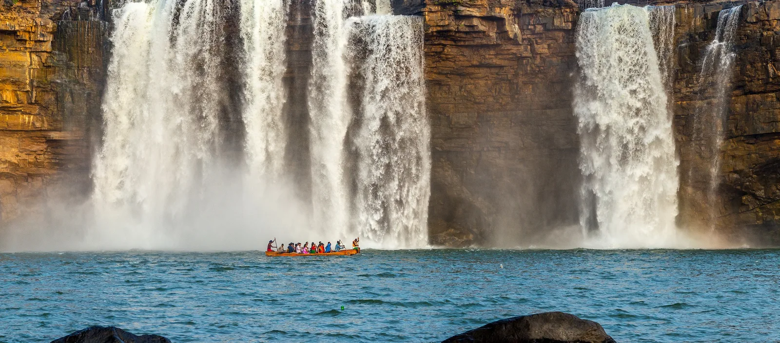
Chitrakote Falls, on the Indravati River in Bastar district, is India's widest waterfall: the Chhattisgarh Tourism Board puts it at about 300 metres wide in the monsoon, when the river pours over its rim in a horseshoe. Inside Kanger Valley National Park — some 200 sq km of sal and teak forest, a national park since 1982 and on UNESCO's Tentative List since February 2025 — Tirathgarh Falls, 35 km from Jagdalpur, drops in seven tiers, and Kotumsar Cave runs nearly 200 m underground but is closed from mid-June to mid-October for monsoon flooding. The circuit's temple is Danteshwari Temple at Dantewada, one of the 52 Shakti Peeths, and Jagdalpur's airport has scheduled flights to Raipur and Hyderabad.
SECTION 01Chitrakote Falls: The Indravati's Wide Horseshoe
Begin with the river, because the waterfall is simply where it leaves the plateau. The Bastar district administration's tourist-places listing states it plainly: Chitrakote Waterfall is a waterfall on the river Indravati in Bastar district of Chhattisgarh, west of Jagdalpur, the town every Bastar trip is based in. Incredible India, the Ministry of Tourism's portal, describes what the river does there in the rains: during the monsoon the Indravati plummets in a horseshoe shape, making it the widest waterfall in India.
The width has an official number, and it belongs to the state itself. The Chhattisgarh Tourism Board presents Chitrakote as India's widest fall, at about 300 metres — a monsoon figure, measured when the Indravati is in full flow and the separate channels over the rim merge into one continuous curtain. The qualification matters: the 300 metres is the river at its biggest, not a promise for every month of the year.
The height, by contrast, has no official number this guide could read — and so none is printed. A precise height appears in guidebooks and on Wikipedia, but no page of the Tourism Board, the district administration or the Ministry of Tourism read states one for Chitrakote, and a waterfall's drop is exactly the kind of fact that gets copied from site to site until it looks established. The width the state itself publishes is the honest superlative here.
Incredible India's Chitrakote page records boating in the Indravati below the falls in the dry season, and its Jagdalpur experiences describe a ride in a country boat towards the waterfalls — the plunge pool is calm enough to approach when the river is low. The same pages note deer, leopards and monkeys around the gorge.
SECTION 02Monsoon or After: Two Different Trips
Bastar's calendar forces a choice, better made deliberately than discovered at a locked cave gate. Come in the monsoon and you get the headline: the Indravati at full width, the horseshoe filled wall to wall, the falls at the roughly 300-metre breadth the Tourism Board advertises. The price is the rest of the circuit — the district administration states that Kotumsar Cave floods in the monsoon and is closed to tourists from the middle of June to the middle of October.
Come in the months after the rains and the bargain reverses. The river drops; expect the curtain to narrow into distinct streams across the horseshoe rim and the plunge pool to calm — the season Incredible India's boating belongs to. In exchange, the whole circuit opens: the caves are enterable once their closure lifts in mid-October, and Tirathgarh runs full inside a washed-green park. For most first-time visitors the strongest window is late autumn into winter — after the caves reopen, while the falls still carry post-monsoon water: not the widest Chitrakote of the year, but the only one with the rest of Bastar attached.
One local date sits inside the monsoon rather than avoiding it: Incredible India's Chitrakote page records the Goncha Festival, held annually in July. If the festival, or the falls at their fullest, is your reason, travel in the rains and accept the closed caves.
SECTION 03Tirathgarh Falls: The Staircase in the Forest
Chitrakote is width; Tirathgarh is descent. The district administration's listing fixes the logistics — Tirathgarh is situated 35 kilometres from Jagdalpur — and the Tourism Board fixes the form: a seven-tiered cascade on the Kanger River, inside Kanger Valley National Park, where the river steps down a long staircase of rock ledges instead of jumping once. Steps follow the tiers down, so the falls are experienced as a descent through forest rather than a single viewpoint, the full drop assembling itself only at the bottom.
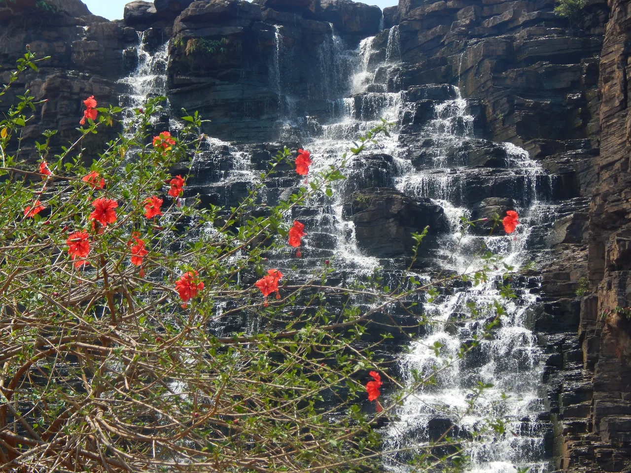
The same honesty rule applies here: a precise height is attached to Tirathgarh in most retellings, but no official page read for this guide states Tirathgarh's height, so the drop is left unmeasured; what is printed is the tier count the Board publishes and the distance the district publishes. Tirathgarh is visited on the national park's ticketing — the next section explains why those terms appear here without a rupee figure.
SECTION 04Kanger Valley National Park: The Forest Between the Falls
The park takes its name from its river. The district administration records that the name of Kanger Ghati National Park is derived from the Kanger River, which flows through its length — the same river that makes Tirathgarh on its way. The park's published description, as carried by the district administration, gives the frame: about 200 square kilometres, national park status in 1982; a typical mixed humid deciduous forest in which sal, teak and bamboo are found in abundance; and the Kanger River flowing northwest to southeast, one of the very few perennial rivers of Bastar.
The park's emblem is audible before it is visible. The same official description names the Bastar Hill Myna — the state bird of Chhattisgarh — as the park's most popular species, a bird capable of imitating human voices. In February 2025 the park's standing rose beyond the state: UNESCO's official Tentative List now carries Kanger Valley National Park, entered on 11 February 2025.
Entry is ticketed, with an official online booking channel alongside the gate. But this guide prints no entry fee, deliberately: the park's official tariff page could not be read directly when this guide was checked, and the figures in circulation contradict each other — an older published tariff sits alongside current listings quoting a flat per-person rate. So the mechanism is what is printed: confirm the current tariff — Indian and foreign rates separately — on the park's official site or at the gate before you travel.
SECTION 05Kotumsar and Kailash: The Caves Under the Limestone
The district administration's Kotumsar page is the most scientific document in this guide. Kotumsar is a limestone cave on the Kanger limestone belt, near the bank of the River Kanger, a tributary of the Kolab, named after the nearby village of Kotumsar; its older name was Gopansar — from Gopan, hidden. The entrance, at about 560 metres altitude, is a vertical fissure in the wall of a hill; inside, a concrete path leads tourists to the end of the cave, along a main tunnel nearly 200 metres long with side and downward passages, past the cave's stalactites and stalagmites.
Underground, the climate holds still: the district page records air and water temperatures stable through the year, at annual averages of about 28.25 °C and 26.33 °C. Incredible India's Kutumsar page adds the visitor's shape of the place: the cave system extends over 2 kilometres underground, of which only a part is open to tourists, for safety; there are five chambers, and near the end of the route a stalagmite formation shaped like a Shivalinga, where the cave turns from geology into devotion.
The access rule is absolute, officially stated, and shapes the whole Bastar calendar: the cave is subject to frequent flooding during the monsoon season, which generally begins in the middle of June and continues until the middle of October, and the site is closed to tourists during this period. There is no monsoon workaround; if the caves are the point of your trip, your dates are mid-October onwards. Nor does Kotumsar stand alone: the park's published description names three exceptional caves — Kutumsar, Kailash and Dandak — famous for their geological structures of stalagmites and stalactites. Kailash, the park's second show cave, is treated at exactly that published strength: the official pages read give neither its dimensions nor its closure calendar, so neither is printed — confirm its opening at the park gate.
SECTION 06Danteshwari Temple: Bastar's Presiding Goddess, at Dantewada
Every Bastar itinerary is, in the local understanding, a visit to the goddess's country — so be precise about where her temple stands. The famous Danteshwari Temple is not in Jagdalpur town but at Dantewada, roughly 80 kilometres from Jagdalpur. The Census of India's District Census Handbook for Dantewada district gives the official summary: the temple stands on the sangam — the confluence — of the Dankini and Shankini rivers, and a tooth of Sati, the wife of Shiva, is believed to have fallen here, which made the place famous as an important Shakti Peeth of India. The Tourism Board counts it among the 52 Shaktipeeths.
The handbook dates the fabric as well as the sanctity: the temple was reconstructed in the fourteenth century by Annadev, a brother of Prataprudra of Warangal, and its deity is an eight-armed stone statue of Danteshwari Devi — presiding deity of Bastar's rulers, whose name the district itself carries: Dantewada derives its name from its presiding deity, Devi Danteshwari. It is a working shrine, and the correct etiquette is a pilgrim's, not a tourist's.
Her largest appearance, though, happens back in Jagdalpur. The district's temple history records that the procession of the goddess's idol at Dussehra is part of the Bastar Dussehra festival — the region's great annual gathering, centred on Danteshwari.
SECTION 07Bastar's Heritage: Craft Villages, Weekly Haats and the Museum
Bastar's culture is not a performance laid on for visitors; it is the region's working life, and the official sources describe it best that way. The Chhattisgarh Tourism Board's crafts material credits the region's tribal smiths with a foundational place in India's metalworking — tribals were, in the Board's words, most likely the principal metal smiths of India — and Incredible India's Jagdalpur pages direct visitors to the artisan villages around the town, where wrought iron craft, Dokra (lost-wax) metal art, wooden crafts, stone sculpting, pottery, handloom weaving, painting and jewellery-making are still practised, pointing also to the Gotul, a traditional institution of the region's communities, as a way to encounter its music, dance and food in context.
The living institution a visitor can actually join is the weekly haat: the market day that rotates through Bastar's villages, when forest produce, grain, livestock and the region's craft — ironwork, Dokra figures, terracotta, woven cloth — are traded in one open ground, and the haat doubles as the week's social assembly. Two honest limits belong here. No official haat calendar could be read for this guide — which village hosts on which day is local knowledge, not published data — so ask in Jagdalpur and go in the morning. And a haat is a working market, not an exhibition: buy fairly, ask before photographing people, treat the sellers as traders, not exhibits.
The display case, though, is a good one, and it is in Jagdalpur itself. The Anthropological Survey of India's Zonal Anthropological Museum began, by the Survey's own account, on 11 December 1972 and was formally inaugurated on 7 April 1978; its purpose is documenting and preserving the bio-cultural heritage of the people, with specimens collected from the tribal populations of Bastar district and the adjoining areas. Visit it before the haat, not instead of it: the museum names the objects, the market shows them earning their keep.
SECTION 08Getting There, and Putting the Circuit Together
Jagdalpur is the base for everything in this guide — falls, park, caves, museum and haats all run from it as day trips, with Dantewada the one longer excursion. The town's air link is recent and officially documented. The Press Information Bureau announced that Alliance Air began direct daily flights under the UDAN regional-connectivity scheme from Jagdalpur to Raipur and Hyderabad, flown by 72-seater ATR aircraft, describing Jagdalpur airport as sitting in a tribal district with huge tourism potential for its unique tribal culture and heritage. Parliament has since updated the picture: a Lok Sabha answer of 28 November 2024 records that the routes began on 21 September 2020, that after the three-year RCS tenure IndiGo commenced commercial operations on them, and that Alliance Air continues to operate Jagdalpur–Bilaspur commercially; the airport — named Maa Danteshwari Airport — is owned by the Government of Chhattisgarh.
By land, Jagdalpur is the railhead and road hub for the whole circuit, and Raipur, the state capital, is the larger gateway — far more flights land there, and the onward journey is made on the short connecting flight above or by road. This guide deliberately prints no Raipur–Jagdalpur road distance: the figure is quoted everywhere, but no official page read states it, and the rule that governed the falls' heights governs road distances too. Plan the transfer generously — the last stretch into Bastar is forest road.
Assemble the days around the two fixed points the official record gives you. First, the cave window: Kotumsar's closure, mid-June to mid-October, rules out the monsoon for the full circuit. Second, the river: Chitrakote is at its ~300-metre widest in the monsoon and narrows through the dry season, when boating below it opens. A post-monsoon trip threads both — caves open, falls still broad, Tirathgarh strong inside a green park, haat mornings and the museum between excursions, and a day south to Dantewada.
FAQFrequently Asked Questions
When is Chitrakote Falls at its widest — and what is the catch?
In the monsoon. The Tourism Board's roughly 300-metre width, and Incredible India's description of the Indravati plunging in a horseshoe that makes it India's widest waterfall, are both monsoon statements: that is when the river fills the whole rim. The catch is the rest of the circuit — the district administration states that Kotumsar Cave floods and is closed to tourists from mid-June to mid-October. Go in the rains for the falls alone at full width; go from late autumn, after the caves reopen, for the complete circuit.
How much does entry to Kanger Valley National Park cost?
This guide prints no figure, deliberately. The park is ticketed and runs an official online booking channel, but its official tariff page could not be read directly when checked (5 November 2026), and the numbers in circulation conflict: an older published tariff sits alongside current listings quoting a different flat per-person rate. Confirm the current tariff on the park's official site or at the gate before you travel.
Are the Kotumsar caves open in the monsoon?
No. The district administration's Kotumsar page states that the cave is subject to frequent flooding during the monsoon season, which generally begins in the middle of June and continues until the middle of October, and that the site is closed to tourists during this period. Plan from mid-October onwards if the caves matter to your trip. Kailash Cave, the park's second show cave, follows the park's own calendar — confirm its opening at the gate.
Can I fly to Jagdalpur, or do I have to come via Raipur?
You can fly to Jagdalpur. The Press Information Bureau records Alliance Air starting direct daily UDAN flights from Jagdalpur to Raipur and Hyderabad with 72-seater ATR aircraft, and a Lok Sabha answer of 28 November 2024 updates the position: IndiGo has since commenced on the Raipur and Hyderabad routes, Alliance Air continues to Bilaspur, and the airport (Maa Danteshwari Airport) is owned by the Government of Chhattisgarh. Frequencies are modest and schedules change, so check the live timetable; Raipur remains the fallback gateway with the far larger network.
Is Danteshwari Temple in Jagdalpur?
No — the Shakti Peeth temple stands at Dantewada, roughly 80 kilometres from Jagdalpur, and makes the circuit's temple day-trip. The Census of India's District Census Handbook for Dantewada places it on the confluence of the Dankini and Shankini rivers, records that a tooth of Sati is believed to have fallen there, and notes that Dantewada takes its name from the goddess. She is Bastar's presiding deity all the same: her idol's procession forms part of Bastar Dussehra in Jagdalpur.
Official references and checking status
Checked on 5 November 2026 against the official sources listed below; the accompanying sources file maps each claim to its page. Four limits are flagged honestly. First, no official page read states a height for Chitrakote or Tirathgarh Falls, so none is printed for either, despite the familiar figures in circulation. Second, the park's official tariff page could not be read directly in this pass and published figures conflict, so entry is described without a rupee figure. Third, no official haat calendar could be read, so no village market days are asserted. Fourth, no official page read states a Raipur–Jagdalpur road distance, so none is printed. Confirm current tariffs and timings on the official sites before you travel.
- Bastar District Administration (official) — Tourist Places: Chitrakote, Tirathgarh, the Kanger Ghati name
- Bastar District Administration (official) — Kotumsar Cave: geology, tunnel, temperatures, closure
- Bastar District Administration (official) — Kanger Ghati National Park: area, forest, the three caves
- Incredible India, Ministry of Tourism (official) — Jagdalpur experiences: the widest waterfall, artisan villages
- Incredible India (official) — Chitrakote Waterfalls: boating, Goncha Festival, wildlife
- Incredible India (official) — Kutumsar Caves: the 2 km system, five chambers
- Chhattisgarh Tourism Board (official) — Chitrakote's width, Tirathgarh's tiers, the 52 Shaktipeeths, crafts
- Press Information Bureau (official) — Alliance Air's UDAN flights from Jagdalpur to Raipur and Hyderabad
- Lok Sabha Unstarred Question No. 627, answered 28 November 2024 (Parliament of India) — IndiGo on the Jagdalpur routes; Alliance Air to Bilaspur
- UNESCO World Heritage Centre (official) — India's Tentative List: Kanger Valley, 11 February 2025
- Anthropological Survey of India (official) — the Jagdalpur centre and Zonal Anthropological Museum
- District Census Handbook, Dakshin Bastar Dantewada — Census of India 2011 (official) — Danteshwari Temple
Photos: Chitrakote Falls in full flow with a country boat below the horseshoe, by Shaswat Nimesh, via Wikimedia Commons, licensed under CC BY-SA 4.0; Tirathgarh Falls stepping down its rock tiers behind hibiscus flowers, by Shreyasime, via Wikimedia Commons, licensed under CC BY-SA 4.0. Photographers keep their copyright; the licences require this credit.
General information only. This guide is based on official sources publicly available and checked on the date shown on this page. Visa rules change, and consular and USCIS officers decide every case on its own facts — nothing here is a confirmation or a guarantee for your individual case, and this is not legal advice. Always confirm the current requirement on the official page linked in this guide before you act, and consider a qualified immigration attorney for your specific situation.