
Researched & checked — 5 November 2026
Daman and Diu: Two Portuguese Coasts at Opposite Ends of Gujarat, Planned on Official Facts
NEW Published 5 November 2026
The name promises a pair; the map delivers two separate journeys. Daman is a river town near Mumbai, split by the Daman Ganga into Moti Daman and Nani Daman, each with its own Portuguese fort. Diu is an island off the Saurashtra coast near Veraval, wrapped around a great sea fortress. The UT administration's own road figures put them 768 km apart — so this guide plans them as what they are: two trips sharing a history and an administration, and almost nothing else.
Treat Daman and Diu as two separate trips — the UT administration's road tables put them 768 km apart. Daman is the easy add-on: rail to Vapi (about 12 km), then walk a town the Census Handbook says the Daman Ganga divides into Nani Daman and Moti Daman — the big fort (built 1559–1581, walls enclosing 30,000 sq m and 10 bastions) on one bank, the smaller St. Jerome Fort (about 12,250 sq m) on the other. Diu is the destination trip: an island of 21 km of coastline whose fort was constructed between 1535 and 1541, with the Naida Caves beside it, Nagoa Beach for water sports and Ghoghla Beach — on the Environment Ministry's published Blue Flag list — about 15 km from town. And yes, the UT is not dry: its excise department licenses liquor under the Goa, Daman & Diu Excise Duty Act, 1964, with notified dry days.
SECTION 01One Name, Two Coasts: The Frame Before the Forts
Start with the correction every itinerary here needs. Daman and Diu are two districts of one Union Territory — since 26 January 2020, part of the merged UT of Dadra and Nagar Haveli and Daman and Diu, a merger the Press Information Bureau announced as effective from that date. But they sit at opposite ends of the Gujarat coast. The UT administration's own "How to Reach" tables give the road distance plainly: Daman is 768 km from Diu, and Diu's Municipal Council says the same — the island lies at a distance of about 768 kms from Daman. Nobody sensible tours them back-to-back; you choose a coast, or give each its own days with a long transfer between.
What they genuinely share is the Portuguese frame. The UT's Fort of St. Jerome page records that Daman was taken from its Gujarati ruler by the Portuguese in 1531 but was only officially handed over in 1559, and that Diu became a Portuguese colony in 1539 after a peace treaty with the Sultan of Gujarat. The Diu Municipal Council completes the arc: the Portuguese ruled for nearly 450 years, and Goa, Daman and Diu were liberated on 19-12-1961 from the Portuguese rule during Operation Vijay. The Census of India's Daman handbook adds the sequel: the UT of Daman and Diu came into existence in 1987, when Goa became a state. Nearly 450 years explains the look of both places; 768 km explains why this guide is in two halves.
SECTION 02Daman: The Town the River Splits in Two
Daman's geography is a single sentence in the Census of India: "Daman is divided by the Daman Ganga River into two parts, namely Nanidaman (Nani meaning 'small') and Moti-daman (Moti meaning 'big')." The handbook immediately corrects the names' implication: Nani Daman is the larger of the two towns, the downtown of major hospitals, supermarkets and residential areas, while Moti Daman is mainly the old city, inhabited largely by the fishing community and government officers, with most public offices located there. Bridges join the two banks, and a Daman day naturally crosses between them: the commercial bustle, hotels and the Devka seafront on the Nani side; the walled old town, its churches and its quiet on the Moti side.
Each half keeps its own fort, facing each other across the river. The big one — Moti Daman Fort — is a walled town in itself (Section 03). The small one, the Fort of St. Jerome in Nani Daman, stands on the riverbank and can be walked in under an hour (Section 04); its ramparts overlook the fish market and the small fishing fleet which anchors alongside, in the administration's words. Plan Daman as a slow two-bank walk: heritage in the morning cool, the seafronts toward evening.
SECTION 03Moti Daman Fort: A Walled Town, Not Just a Fort
The UT administration dates the great fort precisely: "The construction of Moti Daman Fort commenced in A.D. 1559 and concluded in A.D. 1581 when Daman was a Portuguese enclave." Its walls encompass a large area of 30,000 square meters — and what they enclose is not a ruin but the functioning old town: the administration's own interior inventory lists the Administrator's Secretariat, the Government House, the Cathedral of Bom Jesus, the Dominican Monastery, Bocage House (the poet house), the old lighthouse, the convent school, government quarters, the district library, three gardens, the district court and the Daman Municipal Council. Most areas, the same page says, are accessible to the general public for visiting, and stairs at multiple points lead up to walk the walls around the 10 bastions — river mouth on one side, tiled rooftops on the other, the single best hour in Daman.
Inside, two buildings earn the stop. The Cathedral of Bom Jesus is dated by the Tourism Ministry's Incredible India itinerary to 1559, the fort's founding moment, and singled out for its intricately carved gateways, ornate interiors, and artistic wooden altars, which have endured the test of time. Nearby stands the beautiful counterweight: the Dominican Monastery, the "Ruined Church" — said to have been erected in 1567 in remembrance of Saint Dominic, once the most prestigious church in the territory, its destruction believed to have been caused by an earthquake, and usually open until the sundown. Look also for the House of Bocage just inside the entrance, named for the Portuguese poet deputed to Goa in 1786; its indoor area is locked, so it is an exterior stop. And follow this guide's rule on fees: no official tariff or fort timing could be read on the administration's pages, so none is printed — go in daylight and confirm at the gate.
SECTION 04St. Jerome's Fort, Devka and Jampore: Daman's Other Half
Cross to Nani Daman for the second fort. The Fort of St. Jerome is, in the administration's description, a small fort with high and elegant stone walls, three bastions and two huge gateways, spread over about 12,250 sq m on the bank of the Daman Ganga. Its river-facing gateway carries a large statue of St. Jerome, and inside stands the Church of Our Lady of the Sea, which the administration describes as an extension of an ancient chapel constructed in the year 1627, with an excellent altar and superb panelling. The administration's own visiting advice is worth printing verbatim in substance: Daman's churches are usually closed around 5:30 p.m., so do the churches before evening. Gandhi Park, near the Nani Daman Jetty, adjoins the stop.
Daman's two named beaches divide the day's ends. Devka Beach, on the Nani Daman side, is the developed seafront: the administration calls it massive, picturesque and quite unspoilt, with clean waters, well-maintained shores and a special amusement park housing huge fountains and a play area for kids; the UT tourism department's newer NAMOPATH — Devka Seafront is promoted for calm waters and sunset views. Jampore Beach, across in Moti Daman, is the opposite temperament: the administration places it remotely, 5 kilometers away from the Moti Daman Jetty, and describes a beach famous for its blackish mud-colored water, tree-covered and breezy, a perfect place for the ones seeking some peace and solitude. No official entry tariff for either beach could be read, and none is printed here.
SECTION 05Diu: The Sea Fortress and the Quarry Caves
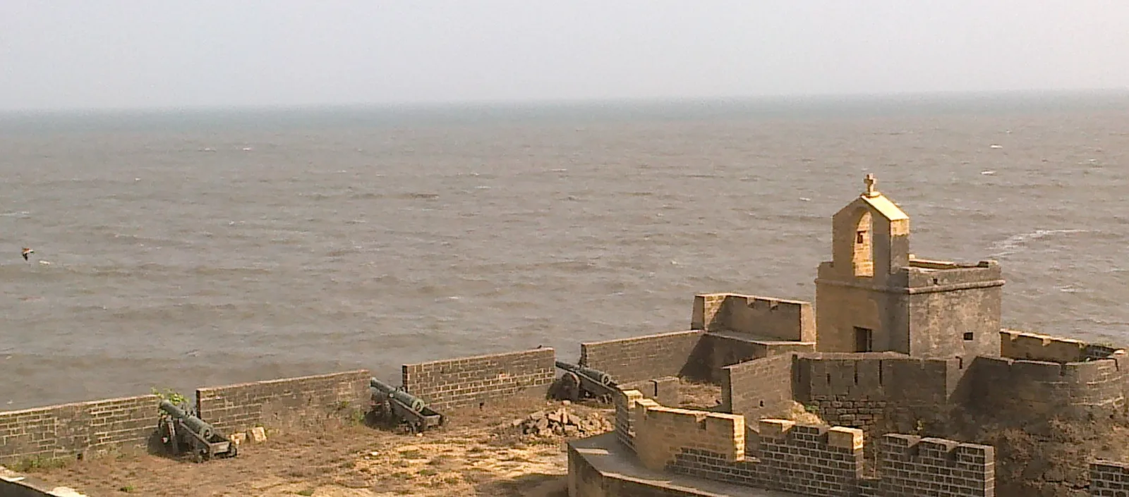
Diu is an island, and it feels like one. The Municipal Council places it slightly off the coast of Saurashtra (Kathiawad) near the port of Veraval, with a coastal distance of 21 kms — a half-day's wandering, not a checklist. Its anchor is the fort: the Fort of Diu was constructed between 1535 and 1541 AD after a defence alliance, concluded by the Bahadurshah, Sultan of Gujarat, and the Portuguese when the former was attacked by Humayun, the Mughal Emperor, in the administration's account. It is skirted by the sea on the three sides; a giant structure on it now houses a lighthouse; several cannons still stare from the top, and mounds of iron shells can still be seen inside. Incredible India's advice matches the ground: climb to the highest point, where the sea view opens out. As at Daman, no official entry fee or hours could be read, so none is printed; give the fort a full morning regardless.
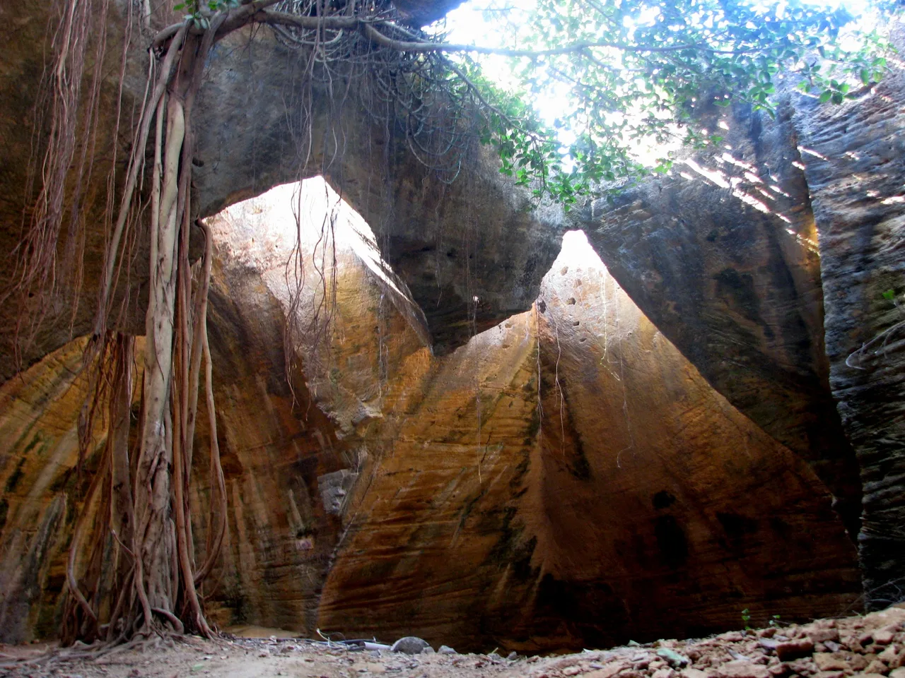
Immediately outside the fort's city wall sits Diu's strangest sight. The Naida Caves, in the administration's words, feature a big network of tunnels with square hewn steps, which is yet to be fully explored, and were constructed by the Portuguese. They are best understood as the fort's quarry: it is believed that the Portuguese hacked building materials for constructing the fortress of Diu from these caves. The administration also passes on the local story — labelled as what the locals say — that Portuguese soldiers hid from the Indian Army inside the caves during Operation Vijay in 1961. Go in the morning, when the light shafts through the openings do their work, and wear shoes with grip.
SECTION 06Diu: Churches, a Sea-Washed Temple and a War Memorial
Diu town's churches compress the Portuguese centuries into two stops. St. Paul's Church — dedicated to Our Lady of Immaculate Conception — is dated by the UT administration to 1691 and described as the only church in operation in Diu till date and the biggest Portuguese Catholic church on the island. Its fame is its woodwork, which the administration calls the most elaborate of all the Portuguese churches in India, with volutes and shell-like motifs across a Gothic-style facade. Beside it, the St. Thomas Church, built in 1598 and once Diu's first parish church, now houses a museum of archaeological artefacts and historical relics. A short boat ride away — Incredible India puts it about a nautical mile from Diu Jetty — the sea fortress of Panikotha rises from the water: built by Malik Aiyaz in the Muslim-rule period and fortified by the Portuguese in 1588, per the UT tourism department.
Two stops of a different register complete the town. At Gangeshwar Temple, the UT tourism department describes a cave temple where the rhythmic lapping of the gentle sea waves against the rocks sets the mood; Incredible India adds the substance — five sacred Shivalingas that the waves wash over. And on a hillock by Chakratirth Beach stands the INS Khukri Memorial: a tribute to the brave soldiers who lost their lives during the Indo-Pak war of 1971, where a scaled model of the INS Khukri is encased in a glass house, in Incredible India's description. The Navy's account, carried by the Press Information Bureau, gives the loss its weight: the Khukri sank on the night of 9th December 1971 with 18 officers and 176 sailors, including her commanding officer, Captain Mahendra Nath Mulla, who stayed courageously on the Bridge as the ship went down and was later awarded the Maha Vir Chakra posthumously. No official entry fee for the memorial could be read, so none is printed.
SECTION 07Diu's Beaches: Nagoa's Curve and Ghoghla's Blue Flag
Diu's swimming beach is Nagoa. The UT tourism department describes it as captivating visitors with its picturesque semi-circular coastline, ideal for swimming, sunbathing, and enjoying the peaceful ambiance under swaying palm trees; Incredible India calls the crescent the island's crown jewel and notes the range of water sports based there. The department's activity pages place wind surfing and water scooters at Nagoa and Ghoghla from October to May — the season to aim at. Nagoa is also where the island's airport sits, so many visitors meet the beach before the town.
For quiet, drive the coast road to Ghoghla Beach. The administration places it in the village of Ghoghla, around 15 km from the main town of Diu, notes its tourist complex with basic amenities and its parasailing and water scooters, and observes that fewer tourists are the reason for a much cleaner Ghoghla beach compared to the other beaches in the town. A Tourism Department document calls it the largest and gentlest beach of Diu. Its distinction is certified: the Press Information Bureau, publishing the Environment Ministry's list of Indian beaches conferred with the internationally recognized Blue Flag Certification, names "Ghoghla (Diu)" among them. Blue Flag is an eco-label audited against bathing-water quality, safety and environmental management — at Ghoghla it means the maintained, lifeguarded end of Diu's coast. One honesty note: the UT tourism page still describes Ghoghla as aspiring to the certificate; the ministry's published list is the stronger record, and this guide follows it.
SECTION 08Reaching Each Coast, the Seasons, and the Liquor Question
Reaching Daman. The administration's tables are unambiguous: the nearest railhead is Vapi, located around 12 km away, on the Mumbai–Ahmedabad route of the Western Railway, where major Delhi–Mumbai and Mumbai–Ahmedabad bound trains halt; from Vapi, local buses and taxis cover the last stretch, and Vapi itself sits on the Mumbai–Ahmedabad National Highway. By road the administration gives Mumbai 170 km, Surat 110 km, Vadodara 300 km and Ahmedabad 360 km; the nearest airports are Mumbai (170 km) and Surat (90 km). Daman is, in short, the easiest Portuguese detour on the Mumbai–Surat corridor.
Reaching Diu. Every Diu attraction page of the administration repeats the same three routes. By air, Diu has an airport at Nagoa connected by flights from Mumbai and Ahmedabad — carriers and schedules change, and the administration names neither, so check current services first. By rail, the nearest railway junction is Veraval, 90 km from Diu, connected directly to Mumbai, Ahmedabad, Pune and Dwarka; closer still, the metre-gauge station at Delwada is just 8 km from Diu, with daily two trains connecting Junagadh and Veraval to Delwada. By road, the administration lists Ahmedabad 370 km — state and private buses make the trip in around 10 hours — Vadodara 595 km and Mumbai 950 km. Onward, Incredible India places Somnath about 85 km west of Diu, making the island a natural end or start to a Saurashtra temple circuit.
Seasons. Incredible India's Diu verdict is the planning line: the island's temperate climate is welcoming throughout the year, but the cooler weather from October to March is ideal — which is also the administration's October-to-May water-sports window at Nagoa and Ghoghla. Daman is the year-round weekend instead, busy in the monsoon by design: the Tourism Ministry's calendar even lists a Monsoon Festival among its Daman attractions. For forts and wall walks anywhere, mornings are the comfortable hours in every season.
The liquor question. Travellers arrive from Gujarat assuming prohibition follows them; inside the UT it does not, and the evidence is the administration's own paperwork. The UT has an Excise Department administering liquor under the Goa, Daman & Diu Excise Duty Act, 1964 and its 1964 Rules: its notifications fix licence fees, excise duty, import duty and the maximum retail price of liquor for wholesale and retail sale in the UT, grant permissions to hoteliers, retailers, bars and restaurants, and refer throughout to licensed premises for the sale and service of liquor throughout the U.T. of Daman & Diu — a licensed trade, not a banned one. The same file shows the limits: the department declares dry days, ordering licensed premises closed on days such as 2 October (Gandhi Jayanti) and Mahavir Jayanti, and on election counting days, when storing liquor in unlicensed premises without a permit is separately prohibited. So: drink legally at licensed premises inside the UT, expect notified dry days, and do not treat the licence as portable — check the rules before carrying anything across the border into Gujarat.
FAQFrequently Asked Questions
Are Daman and Diu next to each other? Can I cover both in one short trip?
No — and this is the fact the shared name hides. The UT administration's road tables put Daman 768 km from Diu, and Diu's Municipal Council gives the same figure. Daman sits on the south Gujarat coast near Vapi, on the Mumbai–Ahmedabad corridor; Diu is an island off the southern Saurashtra coast near Veraval. Give each its own days, or pick one: Daman as the Mumbai-side weekend, Diu as the destination, possibly paired with Somnath, about 85 km away.
Is alcohol legal in Daman and Diu, since Gujarat is a dry state?
Inside the Union Territory, yes — under licence. The UT administration's Excise Department documents administer liquor under the Goa, Daman & Diu Excise Duty Act, 1964: they fix licence fees, excise duty and maximum retail prices, license shops, bars, restaurants and hotels across the UT, and set notified dry days (for example 2 October and Mahavir Jayanti) when licensed premises must close. The UT is not governed by Gujarat's prohibition. But the licence is territorial — check the rules before carrying liquor across the border into Gujarat.
What are the entry fees and opening hours for the forts?
This guide prints none, because no official tariff or timing table could be read: the UT administration's pages for the three forts describe the monuments without publishing an entry fee or opening hours. Two official time notes do exist — the Dominican Monastery in Moti Daman is "usually open until the sundown", and the administration advises that Daman's churches usually close around 5:30 p.m. Plan fort visits in daylight, churches before evening, and confirm any charge at the gate.
How do I reach Diu without driving?
Three official routes, per the UT administration. Fly: Diu's airport at Nagoa is connected by flights from Mumbai and Ahmedabad (the administration names routes, not carriers — check current schedules). Rail: the junction is Veraval, 90 km away, with direct connections to Mumbai, Ahmedabad, Pune and Dwarka; the closest station is metre-gauge Delwada, just 8 km from Diu, served by two daily trains from the Junagadh–Veraval side. Bus: state-run and private buses serve Diu from Ahmedabad, a journey of around 10 hours.
Which Diu beach holds the Blue Flag, and which beach is for water sports?
Ghoghla, about 15 km from Diu town, is the certified one: the Press Information Bureau's publication of the Environment Ministry's list names "Ghoghla (Diu)" among the Indian beaches conferred with the Blue Flag Certification. It is also the quiet end of the coast, with a tourist complex, parasailing and water scooters. Nagoa, the semi-circular bay near the airport, is the busier swimming and water-sports beach — the UT tourism department runs wind surfing and water scooters at both beaches from October to May.
Official references and checking status
Checked on 5 November 2026 against the official sources below; the accompanying sources file maps each claim to its page. Five limits are flagged honestly. First, no entry fee or fort opening hours are printed: the UT administration's attraction pages publish none that could be read, and the opening-hours listings attached to the district websites' map entries are not administration text and were not used. Second, St. Paul's Church at Diu is dated 1691 because that is the UT administration's own dating on its attraction page, which also calls the church "around 400-year-old". Third, Diu's air links are stated only as routes (Mumbai and Ahmedabad) because the administration names no carriers or schedules, and those change. Fourth, on Ghoghla's Blue Flag: the UT tourism page still calls the beach an aspirant, while the Environment Ministry's list published by the Press Information Bureau names Ghoghla (Diu) as certified — the guide follows the ministry. Fifth, the Naida Caves' 1961 hiding story is carried as the local account the administration itself labels it, not as established fact. Confirm current prices and timings before you travel.
- UT Administration of DNH & DD (official) — The Fort of Moti Daman: dates, area, contents, bastions, access
- UT Administration (official) — Fort of St. Jerome, Daman: the 1531/1559 frame, the fort, Our Lady of the Sea
- UT Administration (official) — Dominican Monastery, Moti Daman: 1567, the earthquake tradition, open until sundown
- UT Administration (official) — Church of Our Lady of the Sea: the 1627 chapel, churches closing about 5:30 p.m.
- UT Administration (official) — Devka Beach, Nani Daman
- UT Administration (official) — Jampore Beach: 5 km from Moti Daman Jetty, the mud-coloured water
- UT Administration (official) — Diu Fort: constructed 1535–1541, the sea on three sides, reaching Diu
- UT Administration (official) — Naida Caves: tunnels and hewn steps, the quarry tradition, Delwada
- UT Administration (official) — St Paul's Church, Diu: dated 1691, the wood carving
- UT Administration (official) — Ghoghla Beach: 15 km from Diu town, facilities and water sports
- UT Administration (official) — Excise Department documents: licences, MRP, dry-day circulars under the 1964 Act
- Diu Municipal Council (official) — Introduction: liberation on 19-12-1961, 768 km from Daman, 21 km coast
- Census of India 2011 — District Census Handbook, Daman: the river's division, liberation, the 1987 UT
- Incredible India, Ministry of Tourism (official) — Diu: the fort, St. Paul's, Panikotha, INS Khukri, Gangeshwar, seasons
- Incredible India (official) — The Coastal Charms itinerary: Moti Daman Fort 1559–1581, Bom Jesus, Our Lady of the Sea
- Department of Tourism, DNH & DD (official) — Diu places: Panikotha fortified 1588, St. Thomas museum, Nagoa, water sports October–May
- Press Information Bureau (official) — Blue Flag standards: Ghoghla (Diu) among the certified beaches
- Press Information Bureau / Indian Navy (official) — the INS Khukri tribute: 9 December 1971, 18 officers and 176 sailors, Captain Mulla
- Press Information Bureau (official) — the new Union Territory formed by merger, effective 26 January 2020
Photos: Diu Fort's ramparts, cannons and chapel tower above the Arabian Sea, by Sumit sharma, via Wikimedia Commons, licensed under CC BY-SA 3.0; inside the Naida Caves near Diu Fort, by Rashmi.parab, via Wikimedia Commons, licensed under CC BY-SA 3.0. The licences require this credit.
General information only. This guide is based on official sources publicly available and checked on the date shown on this page. Visa rules change, and consular and USCIS officers decide every case on its own facts — nothing here is a confirmation or a guarantee for your individual case, and this is not legal advice. Always confirm the current requirement on the official page linked in this guide before you act, and consider a qualified immigration attorney for your specific situation.