
Researched & checked — 3 Nov 2026
Mahabaleshwar and Lonavala: The Sahyadri Hill Stations, Planned on Official Facts
NEW Published 3 November 2026
Maharashtra's two famous hill stations sit in the same Sahyadri range but run on different facts: one is a high plateau of named viewpoints, a boating lake and a strawberry garden, protected as an eco-sensitive zone; the other is a monsoon town on the Mumbai–Pune line with a famous dam, two forts and ancient Buddhist caves. Every claim here comes from Maharashtra Tourism's pages, the Archaeological Survey of India's monument texts, or official records — and where no official figure could be read, none is printed.
Lonavala is the close one: Maharashtra Tourism puts it 84 km from Mumbai and 65 km from Pune by road, with its own station on the Mumbai–Pune line. Its highlights are Bhushi Dam in the monsoon, Tiger's Leap, the forts of Rajmachi and Lohagad, and the Karla and Bhaja caves — Karla's great chaitya hall being, on the ASI's record, the grandest and largest of all the chaitya-grihas of India. Mahabaleshwar is the high plateau: Wilson Point, at 1,439 m, is its highest point; boating runs on Venna Lake; and Pratapgad Fort, about 24 km away and built in 1656, is the standard day trip. Both towns sit under district monsoon safety orders (Section 07).
SECTION 01Two Towns, One Range: How They Differ and How to Split Your Days
The two towns share a range — Maharashtra Tourism's Lonavala page describes the setting as the Western Ghats, which it notes are a UNESCO World Heritage site — and a season, but not a character. Lonavala is the escape hatch. It sits on the Mumbai–Pune corridor, has its own station with frequent trains, and packs in a dam, viewpoints, two forts, a lake and two ancient cave groups. It works as a weekend from either city.
Mahabaleshwar is the destination. It is a plateau town at the top of the range — its highest point, Wilson Point, stands at 1,439 m — reached by climbing roads from Satara or Pune, and its pleasures are slower: a circuit of viewpoints, an afternoon on Venna Lake, a temple at the town's ancient core, a garden built around strawberries, and a half-day out to Pratapgad Fort. The whole plateau region is also a notified eco-sensitive zone (Section 03).
Split your days accordingly. From Mumbai, Lonavala alone makes a complete short trip; Mahabaleshwar deserves its own journey, with at least two nights on the plateau — Maharashtra Tourism's tables put it 271 km from Mumbai. Combining the two is possible: route through the Pune side, allow a transfer day, and never attempt Mahabaleshwar as a day trip from a Lonavala base. In the monsoon both towns peak at once (Sections 07 and 08) — the most rewarding combination, and the one needing the most slack.
SECTION 02Mahabaleshwar's Points: Arthur's Seat, Wilson Point, the Elephant's Head and Lingmala
Mahabaleshwar's viewpoints — "points", in local usage — are the town's organising feature, and Maharashtra Tourism describes the principals carefully. Arthur's Seat is called the "Queen of All Points": its subject is the deep Savitri River Gorge; it is named, the department records, after Arthur Malet, with the plateau curiosity that small porous stones there appear to float on water.
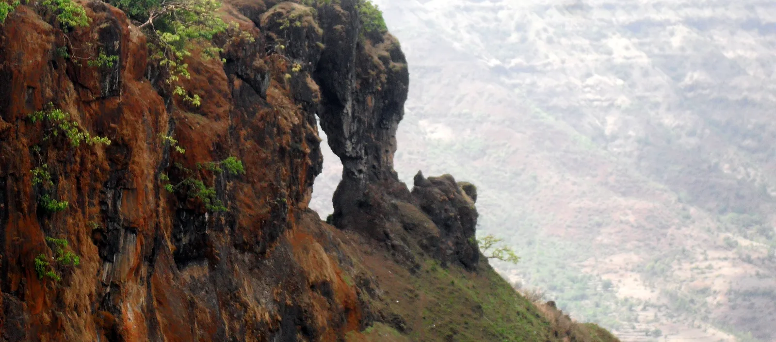
Wilson Point, at 1,439 m, is the highest point in Mahabaleshwar. The department also calls it Sunrise Point: it has three watchtowers, one of the few places in the area where both sunrise and sunset can be observed — worth visiting twice in a stay. Elephant's Head Point, also called Needle Hole Point, is the plateau's signature formation: a rock that, in the department's description, resembles an elephant's head and trunk, pierced by a natural hole — the most photographed feature in town.
The plateau's waterfall is Lingmala Waterfall, described by Maharashtra Tourism in two levels: a smaller fall where visitors take a dip, and the main fall, plunging some 600 feet. Its season is explicit — the falls are at their best in the monsoon, June to September. Treat the dip with Section 07's caution; the department warns that safety is crucial at viewpoints and on trekking routes, where some paths are steep and uneven.
SECTION 03Venna Lake, Mapro Garden, the Old Temple — and a Plateau the Law Protects
The town's gentler circuit runs on three stops. Venna Lake is the activity centre: Maharashtra Tourism lists boating in paddle boats and rowboats, horseback riding along the shore, and lakeside snack stalls. No boating tariff is published on the page read, so none is printed here. Mapro Garden is the strawberry stop: strawberry plantations, and the shakes, ice creams and chocolates made from them, plus a nursery, a chocolate factory and a juice unit. Its calendar anchor is the annual Strawberry Festival, held during the summer; the page read publishes no dates, so check the department's channels nearer the season.
The town's oldest layer is its temple core: Maharashtra Tourism records an ancient Mahabaleshwar Temple dedicated to Lord Shiva, and frames the town's later history in two moves — Shivaji used it as a military base for its strategic importance; the British made it a summer retreat. All of it sits inside a legal frame most hill stations lack: the Mahabaleshwar–Panchgani Region was declared an Eco-sensitive Zone by a Union Ministry of Environment and Forests notification in January 2001, under the Environment (Protection) Act, 1986. The notification restricts industries and development in the zone and requires a Zonal Master Plan and a Tourism Master Plan with emphasis on eco-tourism. One honesty note: no official page read publishes a municipal entry or eco fee for Mahabaleshwar, so none is printed.
SECTION 04Pratapgad: The Fort Day Trip
Mahabaleshwar's one essential excursion is Pratapgad Fort, about 24 km from the town. Its facts are spare: the fort was built in 1656, and it is the ground of the Battle of Pratapgad of 1659, in which Shivaji confronted Afzal Khan — a defining episode of Maratha history. Where the points are about looking out, Pratapgad is about looking back: the same Shivaji who held Mahabaleshwar as a military base built and fought here within a few years.
Plan it as a half-day, keeping the viewpoints for the clearer end of the day; in the monsoon allow extra time for fog and slippery going. No entry fee or timing is printed — Maharashtra Tourism's page states none — so carry small cash and read the board at the gate.
SECTION 05Lonavala: Bhushi Dam, Tiger's Leap, the Forts and Pawna Lake
Lonavala's emblem is Bhushi Dam, which Maharashtra Tourism calls "a monsoon paradise": visitors gather to soak in the overflowing waters, with streams cascading over the dam's steps, and it is a busy picnic spot in the rainy season. That is only half the honest picture. After a tragedy at this spot in 2024, the Pune district administration's monsoon orders have named Bhushi Dam and restricted what visitors may do in its waters. Section 07 states those orders in full; treat the steps as a place to watch the water under whatever instructions are in force.
The town's great viewpoint is Tiger's Leap, named — the department says — for its resemblance to a tiger leaping into the valley; panoramic views, rated ideal for sunrise and sunset photography. The forts divide by effort. Rajmachi Fort is the trek: a Maratha-era stronghold of massive ramparts, a trek particularly popular in the monsoon, in mist and past waterfalls. Lohagad Fort is the accessible classic: well-preserved, a fort that served Shivaji, its gates and walls commanding views over Pawna Lake. Pawna Lake itself, an artificial reservoir, is the department's listed base for camping, boating and stargazing. In town, Ryewood Park and Shivaji Udyan provide the green pause, and the department's souvenir advice is edible: Lonavala is famous for chikki, its jaggery-and-nut sweet.
SECTION 06Karla and Bhaja: Two Thousand Years Cut into the Rock
In Maval Taluka, a short distance from Lonavala, the Buddhist caves of Karla were cut into a high spur on the north flank of the Indrayani valley — nearly 100 m up, the Archaeological Survey of India records — on the ancient highway between the seaports of Kalyan and Sopara and the inland cities. The monasteries date between about 60–40 BC and the 4th century AD, all Hinayana except three Mahayana excavations, and their donors ranged from a Maharathi prince and merchant guilds to monks, nuns and lay devotees.
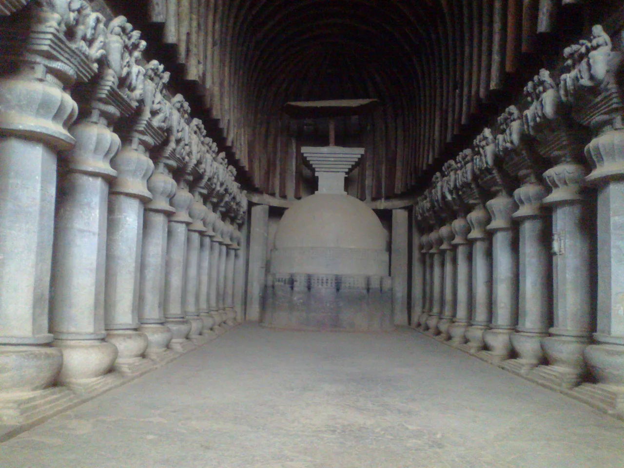
The ASI's own superlative is earned: the grand Chaityagriha of Karla is the grandest and the largest of all the chaitya-grihas of India. The Survey's text gives the hall as 45 m long and 14 m high, its nave lined with 37 octagonal pillars on water-jar bases, their capitals crowded with carved figures. Three entrances — centre to the nave, sides to the aisles — open beneath a huge chaitya window whose light falls on the stupa: a two-stage drum carrying a dome, a cubical harmika and a stepped pyramid crowned by a wooden umbrella. Outside stands one of only two lion pillars before a chaityagriha in the western Deccan (the other is at Kanheri), an Asokan-type pillar with a sixteen-sided shaft.
Its neighbour Bhaja is the older, quieter group: 22 excavations in all, cut into a scarp 120 m above the plains. The ASI dates them from the 3rd century BC to the 2nd century AD, all Hinayana, with occupation continuing to the 5th–6th century AD. Bhaja's chaityagriha is considered the earliest of its kind and a close copy of a wooden prototype: a hall 17.08 m by 8.13 m, its 27 plain octagonal pillars tapering inwards, its vaulted ceiling still carrying original wooden beams. Do not miss Cave 18, whose verandah carries two famous reliefs — a royal figure attended by two women, driving a four-horse chariot over a demonic figure, identified by some as the Sun god Surya; and a figure driving an elephant, goad in hand. One irregular excavation is a cemetery of fourteen rock-cut stupas, some inscribed with the names of the sthaviras (elder monks).
One deliberate silence: no entry fee or opening hours for Karla or Bhaja are printed here. The ASI's monument texts, read via the ENVIS centre's reproductions, carry no fee or hours block, and the Survey's own current pages could not be read at passage level in this pass — while unofficial listings contradict each other. Both sites are ASI-protected and ticketed in practice; check asi.nic.in, or take the price from the counter on arrival. Pair the two in one outing.
SECTION 07The Monsoon, Honestly: What Officials Say About Water, Roads and Selfies
These are monsoon destinations, and the monsoon here is not a drizzle. Maharashtra Tourism's own cautions set the baseline: Mahabaleshwar's rains bring heavy rainfall and fog, with trekking trails slippery — proper shoes and rain gear are the department's advice; for Lonavala it warns likewise that monsoon roads can be slippery. The waterfalls, dam steps and green are at their best exactly when conditions are most treacherous. That trade is the destination; manage it, don't deny it.
What the district administration adds goes further — reported here with its sourcing shown. After 30 June 2024, when a woman and four children were swept away near Bhushi Dam, the Pune District Collector issued prohibitory orders for the district's monsoon spots, as reported by the Press Trust of India: under Section 163 of the BNSS and the Disaster Management Act 2005, in force for July 2024, they covered Bhushi Dam, Tiger Point, Lion's Point, Rajmachi Point, Pavana Dam and other Maval spots, prohibiting gatherings of five or more, entering deep water bodies, selfies and reels at the sites, vehicles within a 1 km radius of waterfalls, and alcohol; with demarcated danger areas, lifeguards and warning boards as the stated measures. In June 2025 the orders were imposed again, reported in force until 31 August 2025, covering the Ekvira Devi Temple, the Karla and Bhaja caves, Bhaje Waterfall, Tiger and Lion's Points and the Lohagad, Visapur and Tikona forts — prohibiting entering fast-flowing streams, swimming in dangerous or deep water, sitting under waterfalls, selfies at waterfall edges, cliffs and steep slopes, and alcohol. A Forest Department monsoon advisory for Pune's hills, forts and waterfalls, likewise press-reported, warns that streams can swell within minutes, advises staying away from fast-flowing water and postponing travel in heavy rain, fog and thunderstorms, and gives a toll-free helpline: 1926.
Two disclosures belong with that account. First, the orders are issued seasonally and reported by the national press agency; the order texts appear on no government page that could be read for this guide, so their content is given as reported by PTI. Second, the pattern matters more than any year's dates: the restrictions have returned in successive monsoons, in similar terms, at the same named places. The working rule: in the monsoon, assume the current year's orders are in force at dams, waterfalls and cliff points around Lonavala; obey the boards, barriers and police on the day over anything printed anywhere, including here; keep out of water where the flow is fast or the bottom unseen; and take the photograph from behind the railing. Mahabaleshwar's points carry the same logic in milder form: fog can cut a view to a few metres in minutes.
SECTION 08Getting There, and When to Come
Reaching Lonavala is the easy half. Maharashtra Tourism calls it a two-hour drive from Mumbai; its essentials box gives road distances of 84 km from Mumbai and 65 km from Pune. By rail it is simpler still: Lonavala has its own station, with frequent trains between Mumbai and Pune. By air, the box lists Pune airport at 68 km and Mumbai's at 88 km. Reaching Mahabaleshwar takes more commitment: the essentials box gives road distances of 57 km from Satara, 121 km from Pune and 178 km from Kolhapur; by rail, Satara at 61 km and Pune at 124 km, its text naming Wathar station, about 60 km away, among the approaches; by air, Pune at 130 km and Mumbai at 271 km. State transport and private buses run from Mumbai and Pune to both. Fly or train to Pune for either town; keep Satara as Mahabaleshwar's rail alternative; and build monsoon delay into every road leg.
The seasons, as Maharashtra Tourism states them for both towns, divide the year the same way — monsoon June to September, winter October to February, summer March to May — but the towns peak differently. For Mahabaleshwar: monsoon is mist and waterfalls in full flow (Lingmala's season); winter is the sightseeing and trekking season of clear gorge views; summer is the cool retreat and the Strawberry Festival's season. For Lonavala, the department is emphatic that the monsoon is the most popular time of all — lush hills, waterfalls and mist, Bhushi Dam overflowing — with the Section 07 orders as the season's standing condition. Its winter is for trekking and sightseeing, its summer a mornings-and-evenings town.
FAQFrequently Asked Questions
Are Mahabaleshwar and Lonavala next to each other? Can I base in one and visit the other?
No — they are two separate bases in the same range. Maharashtra Tourism measures both from Pune: Lonavala 65 km by road, Mahabaleshwar 121 km, so the route between them runs back through Pune's side of the Sahyadris. Lonavala works as a short break from Mumbai or Pune; Mahabaleshwar, 271 km from Mumbai in the department's tables, deserves at least two nights of its own.
Why are there no entry fees or timings for the Karla and Bhaja caves in this guide?
Because no official figure could be verified. The ASI's monument texts for both groups were read through the ENVIS centre's reproductions; they carry no fee or hours block, and the Survey's own current pages could not be read at passage level when checked (3 November 2026). Unofficial listings contradict each other. Both sites are ASI-protected and ticketed in practice — check asi.nic.in, or take the price from the counter on arrival.
Is it safe to get into the water at Bhushi Dam in the monsoon?
Treat it as restricted until the day's instructions say otherwise. Maharashtra Tourism describes the dam's overflowing steps as a monsoon picnic spot; but after a woman and four children were swept away near the dam on 30 June 2024, the Pune district administration imposed prohibitory orders — reported by PTI — covering Bhushi Dam and banning entry into deep water and selfies at the sites, and similar orders returned in June 2025 across the area's dams, waterfalls, caves and forts. Obey the boards, barriers and police on the day, and keep out of fast or unseen water whatever other visitors are doing.
When is Mahabaleshwar's Strawberry Festival, and what else is at Mapro Garden?
Maharashtra Tourism states that the annual Strawberry Festival is held during the summer at Mapro Garden; the page read for this guide (checked 3 November 2026) publishes no dates, so confirm the current year's before planning around it. The department describes Mapro Garden as strawberry plantations with shakes, ice creams and chocolates made from the fruit, No entry fee is published on the page read, so none is printed here.
Which season suits which town?
Maharashtra Tourism divides both towns' years into monsoon (June–September), winter (October–February) and summer (March–May). Lonavala's most popular season, on the department's own statement, is the monsoon — green hills, full waterfalls, Bhushi Dam overflowing — under the Section 07 safety orders. Mahabaleshwar's winter is for sightseeing and trekking, its summer for cool air and the Strawberry Festival. For clear views and comfortable walking in both, October to February is the department's implied choice.
Official references and checking status
Checked on 3 November 2026 against the official sources listed below; the sources file maps each claim to its page. Four limits are flagged honestly. First, entry fees and opening hours for the Karla and Bhaja caves are not printed: the ASI's monument texts, read through the ENVIS centre's reproductions, carry no fee or hours block, the Survey's current pages could not be read at passage level, and unofficial listings conflict. Second, no fee is printed for Pratapgad Fort, Venna Lake boating or Mapro Garden, and no Mahabaleshwar entry or eco fee — Maharashtra Tourism's pages state none. Third, the Pune district's 2024 and 2025 monsoon prohibitory orders and the Forest Department's advisory are described as reported by the Press Trust of India and the press respectively, the order texts not being published on a readable government page; that status is disclosed wherever they are used. Fourth, figures circulating only on unofficial pages — Tiger's Leap's cliff height, Lonavala's altitude, the eco-sensitive zone's surveyed extent — are not asserted. Confirm current prices, timings and any seasonal orders on the official sites before you travel.
- Maharashtra Tourism (official) — Mahabaleshwar: points, Venna Lake, Mapro Garden, temple, Pratapgad, access, seasons
- Maharashtra Tourism (official) — Lonavala: Bhushi Dam, Tiger's Leap, the forts, Karla and Bhaja, Pawna Lake, access, seasons
- Archaeological Survey of India — Karla Caves monument text, reproduced by the CPREEC ENVIS Centre: the great chaityagriha, its pillars, stupa and lion pillar
- Archaeological Survey of India — Bhaja Caves monument text, reproduced by the CPREEC ENVIS Centre: the 22 excavations, Cave 18's reliefs and the stupa cemetery
- Union Ministry of Environment and Forests — notification declaring the Mahabaleshwar–Panchgani Region an Eco-sensitive Zone (January 2001), via the InforMEA legislation record
Photos: Elephant's Head Point (Needle Hole Point) — the elephant-shaped rock above the Mahabaleshwar valleys, by Rishabh Tatiraju, via Wikimedia Commons, licensed under CC BY-SA 3.0; inside the Great Chaitya at Karla, by Amitmahadik100, via Wikimedia Commons, licensed under CC BY-SA 3.0. Photographers keep their copyright; the licences require this credit.
General information only. This guide is based on official sources publicly available and checked on the date shown on this page. Visa rules change, and consular and USCIS officers decide every case on its own facts — nothing here is a confirmation or a guarantee for your individual case, and this is not legal advice. Always confirm the current requirement on the official page linked in this guide before you act, and consider a qualified immigration attorney for your specific situation.