
Researched & checked — 3 Nov 2026
Nainital: The Lake, the Ropeway and the Kumaon Hills, Planned on Official Facts
NEW Published 3 November 2026
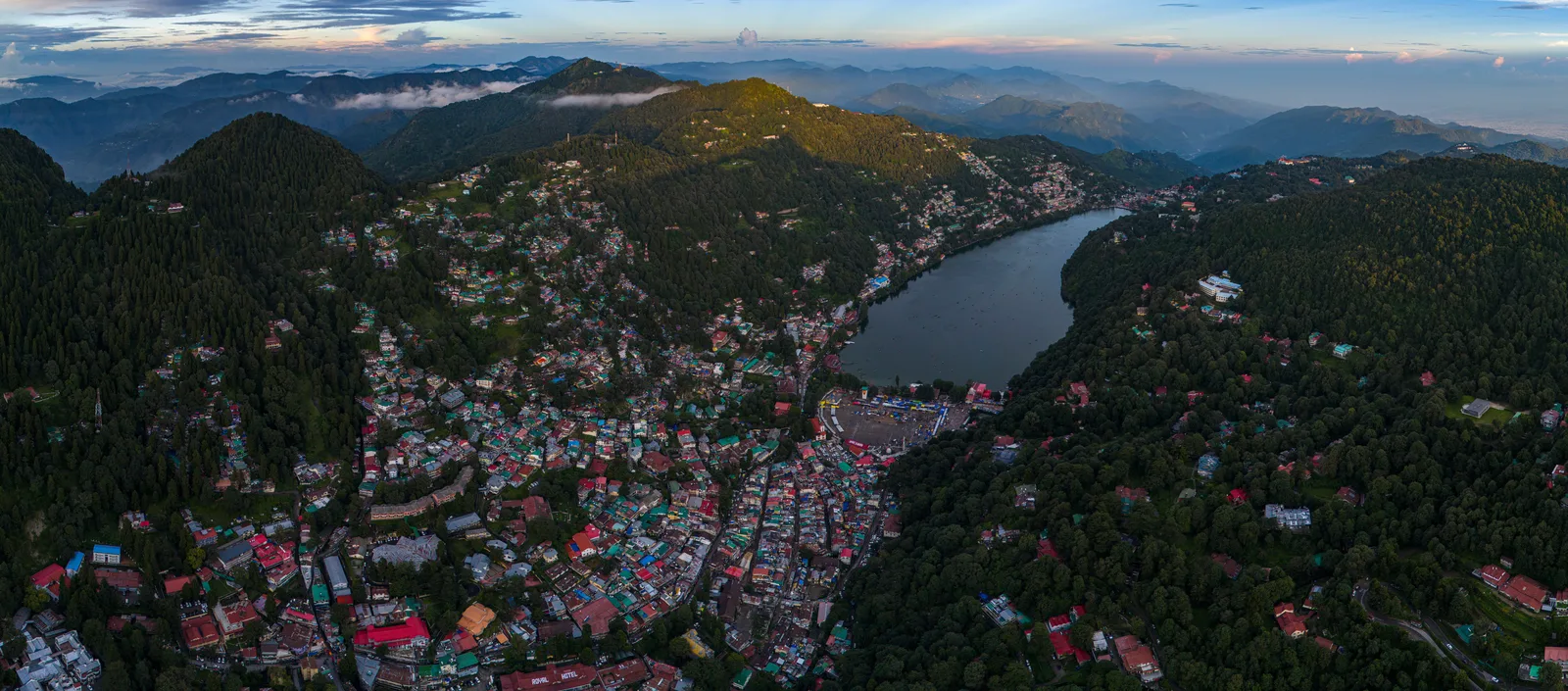
Nainital runs on a short list of checkable facts: a district administration that publishes the ropeway's hours and both-way fare to the rupee, a boating tariff it deliberately leaves to prepaid booths on the lakeside, a railhead 34 km below the town at Kathgodam, and a family of sister lakes. Each fact here comes from the district administration, Uttarakhand Tourism, the Airports Authority of India or the Corbett directorate.
Naini Lake is the town: rowing boats, paddle boats and yachting from both ends of the lake, with rates displayed at prepaid booths on the lakeside — the district publishes no tariff online. The Aerial Ropeway runs from Mallital to Snow View (2,270 m), 10 AM to 4 PM; the both-way ticket is ₹190 for adults and ₹120 for children aged 3–12, and the one-way ride takes about 151.7 seconds. The railhead is Kathgodam, 34 km; the nearest airport is Pantnagar, 70 km. The sister lakes make one day's circuit: Bhimtal 22 km, Sattal about 23 km, Naukuchiatal 26 km. Corbett lies 118 km onward.
SECTION 01Naini Lake: One Lake, Two Ends, and the Whole Town Around It
Start with the district administration's own framing: dotted with lakes, Nainital has earned the epithet of the "Lake District" of India, and the most prominent of its lakes is Naini, ringed by hills at the centre of the town — district headquarters and Kumaon's divisional headquarters. The district's lake page lingers on the view — by day, seven hills stand mirrored in the water; at night the hillside lights stab into the lake. Everything else in this guide is arranged around that one sheet of water.
The lake has two ends, and the district names them precisely. The north end is Mallital; the southern end is Tallital. They are joined by a bridge — the Danth — which carries a statue of Gandhi and, in the district's proud phrase, the only post office on a lake bridge in the whole of the world. The bus station, taxi stand and railway reservation counter stand at the same bridge end, so the town's arrivals and its two halves all meet on the water.
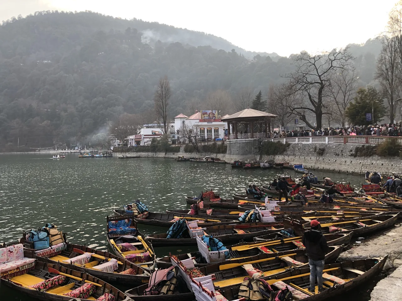
On the water itself, the district is specific about the activity and deliberately unspecific about the price. The lake offers yachting, boating and paddling; rowing boats and paddle boats are available at both ends. And the key sentence: boating rates for conventional rowing boats and paddle boats are displayed on prepaid booths at different places along the lakeside. That is the whole official position — a board at a booth, not a page on the internet. The figures on unofficial sites descend from old listings and disagree with each other, so no boating price is printed here: go to a prepaid booth at Mallital or Tallital and pay the displayed rate — the price quoted to everyone.
SECTION 02Mall Road, the Flatts and the Naina Devi Temple
One side of the lake carries the town's main street. The Mall Road — now named Govind Ballabh Pant Marg — runs along the lake as the main link joining Mallital and Tallital, lined with hotels, restaurants, travel agencies, shops and banks. It also carries the town's best-known traffic rule, and it is a seasonal one: in the summer months of May and June, the Mall Road is closed for vehicular traffic in the evening hours, so that the famous Mall strolling — the evening promenade the district calls a famous attraction for all tourists — can take the road over. That single rule tells you when Nainital's peak is. On the lake's far side lies the quieter Thandi Road, where vehicles are not allowed at all and the Pashan Devi temple stands.
At the northern end, the lake opens into the Flatts, the flat ground at Mallital that the district calls a place of rendezvous for people from all walks of life, heavily crowded in the evenings: a statue of Pt. Govind Ballabh Pant, a band stand, a playing ground for sports and festivals, the Chat Bazar and the Bhotia Market — and, in the periphery, the Boat House Club, home of the lake's yachting.
The Flatts is also where the town's worship gathers. The district's page lists, side by side in the Flatts, a mosque, a gurudwara and the Naina Devi temple — the temple of the goddess who gives both lake and town their name, standing at the northern end of the water. This guide prints no temple timings, because no official temple page publishing them could be read when it was checked; its own notices on the day are the authority.
SECTION 03The Aerial Ropeway to Snow View: 151.7 Seconds Above the Lake
The ropeway is the rare attraction whose operator-side facts the district publishes in full, so this section can be exact. The Aerial Ropeway connects Snow View Point, at 2,270 m, with Nainital near the Flatts; it starts at Mallital, about 200 m on foot from the Mall Road. There are two trolleys, each cabin holding 10+1 passengers or 825 kg, and the one-way journey takes approximately 151.7 seconds — under three minutes from lakeside to ridge. The published timings are 10 AM to 4 PM, and the ticket is sold for the both-way journey: ₹190 for an adult and ₹120 for a child aged 3 to 12 years. Go early in season — two trolleys in a six-hour window is the whole capacity — and treat the hours as a plan, not a promise.
What waits at the top is described by the district on its own Snow View page. Snow View is the most easily accessible hilltop in the town: 2,270 m high and 2.5 km from the town, reached by the ropeway or by a motorable road. As the name promises, it offers a picture of the glittering snows of the Himalayas; there is a temple, tea and snacks at the top. A Himalayan panorama is a clear-day event. In crisp post-monsoon and winter air the range stands out; in summer haze or monsoon cloud the top station gives you the lake and the town instead.
SECTION 04Tiffin Top, Naina Peak and the Cave Gardens: The Viewpoints at Official Strength
Nainital's second viewpoint is a walk rather than a ride. Tiffin Top — Dorothy's Seat — stands 2,292 m above the sea in the Ayarpatta region, 4 km from the town. The district records what the name commemorates: a memorial to an English lady painter, Dorothy Kellet, built by her husband and her admirers after her death, commanding an excellent view of the Himalayas and the neighbouring countryside. Tiffin Top and Land's End sit side by side and, the district advises, can be covered at a stretch. Allow it a morning.
Above both viewpoints stands the town's ceiling. Naina Peak — China Peak — is the highest peak of the town at 2,611 m, 6 km from the town. The district's description earns its place here: the peak commands a view of the snow-laden Himalayas from Bandarpunch in the west to the Api and Nari peaks of Nepal in the east, and a bird's-eye view of the lake city on the other side. Ponies or horses can be hired for the climb, from Snow View or from Barapathhar.
Two more stops sit at the strength the official record gives them. The Govind Ballabh Pant High Altitude Zoo stands about a kilometre from the bus stand at 2,100 m, with — as the district lists them — Himalayan black bear, leopard and Siberian tiger among its animals; it remains closed on Mondays, on national holidays and on Holi and Diwali, and a zoo shuttle runs from the bus station. The district publishes no entry fee, so none is printed. The Eco Cave Gardens, the interconnected cave garden near Mallital that families pair with the lake, is the other honest gap: no official page read for this guide publishes its entry fee or hours, and unofficial listings disagree widely — from nominal sums to three-figure ones. Its gate board on the day is the only rate worth trusting.
SECTION 05The Lake-District Circuit: Bhimtal, Sattal and Naukuchiatal in One Day
Nainital's real depth is that it is one lake among several, and the district measures the others too. The circuit runs through Bhowali, 11 km from Nainital — the road junction serving all the region's routes, which Uttarakhand Tourism's own destination page calls a gateway to the Kumaon region. Loop out of Bhowali and back, and the three lakes fall in order.
Bhimtal comes first: about 22 km from Nainital and 11 km from Bhowali, at 1,370 m. Its pride, in the district's words, is a beautiful lake that is larger than Naini Lake, with boating on it. Mid-lake sits an island with an aquarium, reached by boat — the island lies 91 m from the shore — and along the 40-foot-high dam stands a 17th-century Bhimeshwar temple complex. One road leaves Bhimtal for Naukuchiatal, another for Kathgodam, 21 km away — a detail that matters for the journey home.
Naukuchiatal is the far point: 26 km from Nainital and just 4 km beyond Bhimtal, at 1,220 m. The district's measurements are a small portrait: a pretty, deep, clean lake with nine corners — the name means nine-cornered lake — 983 m long, 693 m broad and 40.3 m deep, offering angling and bird watching, with ample scope for rowing, paddling and yachting.
Sattal closes the loop: about 23 km from Nainital and 12 km from Bhowali, at 1,370 m, a cluster of lakes amidst oak forest that the district compares, wonderfully, with the Westmoreland of England. Its lakes arrive in sequence: first the old Nal Damyanti Lake, then the Panna or Garud lake, and finally the interlinked cluster of three — the Ram, Laxman and Sita lakes. As a day plan the circuit is forgiving: Bhimtal in the morning, Naukuchiatal by midday, Sattal for the afternoon, home by evening — roughly 70 km of hill road, every distance in this section the district's own.
SECTION 06Onward to Corbett: A Note, Not a Detour
Corbett belongs in a Nainital guide as an onward journey, and the district's own Corbett page fixes its scale: the park is 118 km from Nainital via Kaladhungi and Ramnagar, with Ramnagar itself some 60 km away by the same road. The district's summary is compact: Corbett is the first national park of India, established in 1936 as Hailey National Park and renamed in 1957 in memory of Jim Corbett. The main entrance is Dhangarhi, 19 km from Ramnagar, and the nearest railhead is Ramnagar — which is why Corbett works best as the next stay after Nainital, or the one before it, not as a day trip bolted onto a lake holiday.
One set of the reserve's published terms is worth carrying forward, because it shapes both trips: its visitor seasons. By the terms the district reproduces from the reserve's directorate, the Dhikala zone runs 15 November to 15 June, the Bijrani zone 15 October to 30 June, and the Jhirna zone is open round the year — the monsoon closes the park's heartland just as it closes in on the hills. Entry is by permit and an official registered guide is compulsory on all excursions. Book Corbett through the reserve's own channels (linked below), and let Nainital be the hills before or after the forest.
SECTION 07Getting There: Kathgodam, the Hill Road and Pantnagar
Almost everyone arrives the same way, and the district's pages repeat the figures at every attraction like a refrain: 34 km from Kathgodam railway station, 70 km from Pantnagar airport, 40 km from Haldwani bus station. Kathgodam is the railhead — the terminus in the plains below the hills, where the trains end and the road begins. From the station the hill road climbs past Bhowali, gaining in about an hour of fair-weather driving the height the viewpoints measured above. Haldwani, just below the station, is the bus and market base.
By air, the gateway is Pantnagar, the Kumaon region's airport in the plains, 70 km from Nainital by the district's count. The Airports Authority of India, which runs it, describes a small domestic airport in its published fact sheet: elevation 233 m, a single domestic terminal, runway 10/28 and parking bays sized for ATR-72 turboprops — which tells you the scale of the operation and the aircraft to expect. No timetable is printed here; schedules on such routes change with seasons and operators, so check the live position before building a plan around a flight, and hold the Kathgodam trains as the reliable spine of the journey either way.
SECTION 08One Day or Two — and the Season to Pick
One day covers the town itself. Begin at the lake in the early light — a rowing boat from Mallital or Tallital before the booths get busy — then walk the Flatts to the Naina Devi temple while the northern end is still quiet. Take the ropeway inside its 10 AM–4 PM window for Snow View, and spend the middle of the day on the Mall Road. Evening belongs to the Mall again — in May and June, to a road closed to vehicles and given over to strolling. Two days change the trip's character: day one as above, but with Tiffin Top's walk in place of haste, and day two for the lake circuit of Section 05 — returning to Nainital, or dropping from Bhimtal to Kathgodam (21 km by the district's count) if the second evening is a train home. Corbett is a separate stay, not a third day here.
The seasons, as the official record frames them. Summer is the peak: the district's Mall Road rule — evenings closed to traffic in May and June — is the administration planning around its own crowds, and Uttarakhand Tourism's published best months for Bhowali, the district's gateway town, are April to June and September to December, the two windows that frame the rains. The monsoon is the season to plan around, not through: in the wet months the state's emergency machinery treats this district as landslide country — IMD heavy-rain alerts for Nainital district trigger official warnings of landslides and road blockages, and Corbett's core zones shut from mid-June. If you must travel then, build slack into every road leg. Winter is the honest gamble: post-monsoon and winter air gives Snow View its best chance of the Himalayan panorama, and snowfall does reach the town in the coldest weeks — but no official source promises it. Go for the clear views and the quiet; treat snow as a prize.
FAQFrequently Asked Questions
How much does boating on Naini Lake cost?
This guide prints no boating tariff, deliberately — because the district administration doesn't either. Its Naini Lake page states that rates for rowing boats and paddle boats are displayed on prepaid booths along the lakeside, and that boats are available at both ends of the lake (Mallital and Tallital). The figures on unofficial websites descend from old listings and disagree with each other. The prepaid booth is the authority: read its board on the day.
What does the Nainital ropeway cost, and when does it run?
The district administration publishes both. The Aerial Ropeway runs from Mallital (near the Flatts, about 200 m on foot from the Mall Road) to Snow View at 2,270 m, with timings of 10 AM to 4 PM. The ticket is for the both-way journey: ₹190 for an adult and ₹120 for a child aged 3 to 12 years. Two trolleys carry passengers, each cabin holding 10+1 people, and the one-way ride takes approximately 151.7 seconds.
How do I reach Nainital from Delhi?
By train to Kathgodam, then up the hill road. The district's pages consistently measure the town at 34 km from Kathgodam railway station and 40 km from Haldwani bus station. By air, the nearest airport is Pantnagar, 70 km away: the Airports Authority of India runs it as a small domestic airport served by ATR-72 turboprops, so check live schedules before relying on a flight. Either way the last leg is the same climb by road.
Can I see Bhimtal, Sattal and Naukuchiatal in one day from Nainital?
Yes — on the district's own distances. Bhimtal is about 22 km from Nainital via the Bhowali junction (11 km out), with a lake larger than Naini, boating, an island aquarium 91 m from shore and a 17th-century Bhimeshwar temple by the dam. Naukuchiatal is 4 km beyond Bhimtal (26 km from Nainital): a nine-cornered lake, 983 m long and 40.3 m deep, with angling, bird watching and rowing. Sattal, about 23 km from Nainital, is a cluster of lakes in oak forest — Nal Damyanti, Panna (Garud), and the interlinked Ram, Laxman and Sita lakes.
When is the best time to visit Nainital — and will I see snow?
Uttarakhand Tourism's published best months for the district's gateway town of Bhowali are April to June and September to December; the district itself plans for the summer peak by closing Mall Road to vehicles on May and June evenings. The monsoon months are the ones to treat with respect: official heavy-rain alerts for the district warn of landslides and blocked roads, and Corbett's main zones close from mid-June. Winter brings the clearest air and Snow View's best chance of its panorama, and snow does fall in the coldest weeks — but it is weather, not a timetable, and no official source guarantees it. Treat snowfall as a prize rather than a plan.
Official references and checking status
Checked on 3 November 2026 against the official sources listed below; the accompanying sources file maps each claim to its page. Four limits are flagged honestly. First, the district publishes no Naini Lake boating tariff online — it states that rates are displayed at prepaid booths along the lakeside — so no boating price is printed. Second, the Eco Cave Gardens' fee and hours, and the zoo's entry fee, appear on no official page that could be read for this guide, and unofficial listings conflict, so none are printed. Third, Uttarakhand Tourism's Nainital destination page is an interactive page whose text could not be read in this pass; season framing therefore rests on the same board's readable Bhowali page, together with the district's own pages. Fourth, Corbett's visitor seasons are the district page's reproduction of the reserve directorate's terms; the reserve's own site is linked for bookings. Confirm current prices and timings before you travel.
- District Nainital (official) — Naini Lake: the lake's two ends, boating and the prepaid-booth rates
- District Nainital (official) — Aerial Ropeway: timings, both-way fares and journey time
- District Nainital (official) — Tourist Places: Snow View, Mall Road, the Flatts, Tiffin Top, Naina Peak, the Zoo and the sister lakes
- District Nainital (official) — Corbett Tiger Reserve: history, distances and visitor seasons
- Uttarakhand Tourism (official) — Bhowali: the Kumaon gateway and its best months
- Airports Authority of India (official) — Pantnagar airport fact sheet
- Corbett Tiger Reserve (official) — permits, notices and bookings
Photos: Nainital town wrapped around the crescent of Naini Lake at dusk, seen from above, by Harshit SR, via Wikimedia Commons, licensed under CC BY-SA 4.0; rowing boats moored along the Naini Lake shore, by Slyronit, via Wikimedia Commons, licensed under CC BY-SA 4.0. Photographers keep their copyright; the licences require this credit.
General information only. This guide is based on official sources publicly available and checked on the date shown on this page. Visa rules change, and consular and USCIS officers decide every case on its own facts — nothing here is a confirmation or a guarantee for your individual case, and this is not legal advice. Always confirm the current requirement on the official page linked in this guide before you act, and consider a qualified immigration attorney for your specific situation.